Sharing the Colorado River and the Rio Grande: Cooperation and Conflict with Mexico
The United States and Mexico share the waters of the Colorado River and the Rio Grande. A bilateral water treaty from 1944 (the 1944 Water Treaty) and other binational agreements guide how the two governments share the flows of these rivers. The binational International Boundary and Water Commission (IBWC) administers these agreements. Since 1944, the IBWC has been the principal venue for addressing river-related disputes between the United States and Mexico. The 1944 Water Treaty authorizes the IBWC to develop rules and to issue proposed decisions, called minutes, regarding matters related to the treaty’s execution and interpretation.
Water Delivery Requirements Established in Binational Agreements. The United States’ and Mexico’s water-delivery obligations derive from multiple treaty sources and vary depending on the body of water. Under the 1944 Water Treaty, the United States is required to provide Mexico with 1.5 million acre-feet (AF) of Colorado River water annually. The 1944 Water Treaty also addresses the nations’ respective rights to waters of the Rio Grande downstream of Fort Quitman, TX. It requires Mexico to deliver to the United States an annual minimum of 350,000 AF of water, measured in five-year cycles (i.e., 1.75 million AF over five years). For waters of the Rio Grande upstream of Fort Quitman, a 1906 bilateral convention requires the United States annually to deliver 60,000 AF of water to Mexico.
Developments in the Colorado River Basin. The United States continues to meet its Colorado River annual delivery requirements to Mexico pursuant to the 1944 Water Treaty. At the forefront of recent IBWC actions on the Colorado River are efforts to cooperatively manage the Colorado River’s water and infrastructure to improve water availability during drought and to restore and protect riverine ecosystems. Minute 323 is a set of binational measures in the Colorado River basin that provides for binational cooperative basin water management, including environmental flows to restore riverine habitat. Minute 323 also provides for Mexico to share in cutbacks during shortage conditions in the U.S. portion of the basin. Additionally, Minute 323 designates a “Mexican Water Reserve” through which Mexico can delay its water deliveries from the United States and store its delayed deliveries upstream at Lake Mead, thereby increasing the lake’s elevation. Lake Mead elevation is the baseline used for determining shortage conditions and associated water delivery cutbacks for the lower Colorado River basin states of Arizona, California, and Nevada. Recent congressional attention to the Colorado River basin has related largely to oversight of Minute 323 implementation and water management during potential shortage conditions.
Developments in the Rio Grande Basin. On multiple occasions since 1994, Mexico has not met its Rio Grande delivery obligations within the five-year cycle established by the 1944 Water Treaty. For example, Mexico fell 15% below its water-delivery obligations under the 1944 Water Treaty for the five-year cycle from 2010 to 2015. Mexico addressed its deficit by early 2016. The October 2015 to October 2020 cycle is under way. Mexico offset its below-target deliveries for the first year of this cycle with additional deliveries in the second year. IBWC indicates that Mexico delivered less than its 350,000 AF in the third year of the cycle; however, higher deliveries in the second year resulted in Mexico’s deliveries being almost at 98% of the three-year cumulative delivery target of 1.05 million AF.
Some U.S. stakeholders promote the adoption of mechanisms to achieve a water-delivery regime by Mexico that provides more reliability and benefit for U.S. interests in Texas. The IBWC is developing a binational model for water management in the Rio Grande, as part of its broader effort to improve reliability in Mexico’s water deliveries. Congress has been involved in the recent Rio Grande water-sharing issues through oversight. Congress requires the U.S. Department of State to report annually on Mexico’s deliveries and on efforts to improve Mexico’s treaty compliance.
Sharing the Colorado River and the Rio Grande: Cooperation and Conflict with Mexico
Jump to Main Text of Report
Contents
- Introduction
- International Boundary and Water Commission and Water-Related Treaties
- Evolution of the International Boundary and Water Commission
- Structure and Role of the International Boundary and Water Commission
- The Minute Process
- Water Delivery Requirements Established in the 1944 Water Treaty
- Other Provisions of the 1944 Water Treaty
- Post-1944 Border Treaties
- Colorado River Basin
- Salinity
- Instream Flows for Environmental Restoration
- Minute 319: Water Conservation and Environmental Restoration
- Minute 323: Extension and Expansion of Cooperative Measures
- Rio Grande Basin
- Rio Grande Basin to Fort Quitman, TX
- Rio Grande Basin Below Fort Quitman, TX
- Mexico's Rio Grande Deliveries: 2010-2015 Cycle and 2015-2020 Cycle
- Stakeholder Perspectives
- Congressional Responses
- Diplomatic and Technical Responses
- Next Steps and Remaining and Emerging Topics
- Outlook for Binational Water Sharing
Figures
- Figure 1. Illustration of the Colorado River and Rio Grande Basins and the Boundaries of U.S.-Mexico Binational River Basins
- Figure 2. Colorado River Basin
- Figure 3. Rio Grande Basin
- Figure B-1. Drought Monitor for September 2016 through September 2018
- Figure B-2. Evolution of North American Drought from 2011 to 2015
- Figure C-1. Illustration of the Transboundary Nature of Aquifers at the U.S.-Mexico Border
Tables
Summary
The United States and Mexico share the waters of the Colorado River and the Rio Grande. A bilateral water treaty from 1944 (the 1944 Water Treaty) and other binational agreements guide how the two governments share the flows of these rivers. The binational International Boundary and Water Commission (IBWC) administers these agreements. Since 1944, the IBWC has been the principal venue for addressing river-related disputes between the United States and Mexico. The 1944 Water Treaty authorizes the IBWC to develop rules and to issue proposed decisions, called minutes, regarding matters related to the treaty's execution and interpretation.
Water Delivery Requirements Established in Binational Agreements. The United States' and Mexico's water-delivery obligations derive from multiple treaty sources and vary depending on the body of water. Under the 1944 Water Treaty, the United States is required to provide Mexico with 1.5 million acre-feet (AF) of Colorado River water annually. The 1944 Water Treaty also addresses the nations' respective rights to waters of the Rio Grande downstream of Fort Quitman, TX. It requires Mexico to deliver to the United States an annual minimum of 350,000 AF of water, measured in five-year cycles (i.e., 1.75 million AF over five years). For waters of the Rio Grande upstream of Fort Quitman, a 1906 bilateral convention requires the United States annually to deliver 60,000 AF of water to Mexico.
Developments in the Colorado River Basin. The United States continues to meet its Colorado River annual delivery requirements to Mexico pursuant to the 1944 Water Treaty. At the forefront of recent IBWC actions on the Colorado River are efforts to cooperatively manage the Colorado River's water and infrastructure to improve water availability during drought and to restore and protect riverine ecosystems. Minute 323 is a set of binational measures in the Colorado River basin that provides for binational cooperative basin water management, including environmental flows to restore riverine habitat. Minute 323 also provides for Mexico to share in cutbacks during shortage conditions in the U.S. portion of the basin. Additionally, Minute 323 designates a "Mexican Water Reserve" through which Mexico can delay its water deliveries from the United States and store its delayed deliveries upstream at Lake Mead, thereby increasing the lake's elevation. Lake Mead elevation is the baseline used for determining shortage conditions and associated water delivery cutbacks for the lower Colorado River basin states of Arizona, California, and Nevada. Recent congressional attention to the Colorado River basin has related largely to oversight of Minute 323 implementation and water management during potential shortage conditions.
Developments in the Rio Grande Basin. On multiple occasions since 1994, Mexico has not met its Rio Grande delivery obligations within the five-year cycle established by the 1944 Water Treaty. For example, Mexico fell 15% below its water-delivery obligations under the 1944 Water Treaty for the five-year cycle from 2010 to 2015. Mexico addressed its deficit by early 2016. The October 2015 to October 2020 cycle is under way. Mexico offset its below-target deliveries for the first year of this cycle with additional deliveries in the second year. IBWC indicates that Mexico delivered less than its 350,000 AF in the third year of the cycle; however, higher deliveries in the second year resulted in Mexico's deliveries being almost at 98% of the three-year cumulative delivery target of 1.05 million AF.
Some U.S. stakeholders promote the adoption of mechanisms to achieve a water-delivery regime by Mexico that provides more reliability and benefit for U.S. interests in Texas. The IBWC is developing a binational model for water management in the Rio Grande, as part of its broader effort to improve reliability in Mexico's water deliveries. Congress has been involved in the recent Rio Grande water-sharing issues through oversight. Congress requires the U.S. Department of State to report annually on Mexico's deliveries and on efforts to improve Mexico's treaty compliance.
Introduction
The United States and Mexico share a nearly 2,000-mile border and multiple rivers, including the Colorado River and the Rio Grande. Predominantly located in the United States, the Colorado River crosses the U.S.-Mexico border and empties into the Gulf of California. The Rio Grande's headwaters are in the United States, its significant tributaries lie in both the United States and Mexico,1 and its riverbed is the U.S.-Mexico border in Texas. These shared surface waters, which are shown in Table 1, are important to many border community economies and water supplies.
In 1944, the United States and Mexico entered into the Treaty on Utilization of Waters of the Colorado and Tijuana Rivers and of the Rio Grande (hereinafter 1944 Water Treaty),2 which established the International Boundary and Water Commission (IBWC) to oversee the U.S.-Mexico border and water treaties. To date, Congress has been involved in binational water sharing pursuant to the 1944 Water Treaty primarily through oversight. This includes oversight of IBWC's actions to manage the Colorado River's water and infrastructure to improve water availability during drought and to restore and protect riverine ecosystems. On multiple occasions since 1994, Mexico has not met its Rio Grande water delivery obligations to the United States within the five-year period prescribed by the 1944 Water Treaty. Since 2014, Congress has directed the U.S. Department of State to report annually on Mexico's deliveries and on efforts to improve Mexico's treaty compliance.3
This report examines binational sharing of the Colorado River and the Rio Grande and addresses
- the evolution and framework of the IBWC and binational boundary and water treaties;
- Colorado River water sharing background and recent developments; and
- Rio Grande water sharing background and recent developments.
Appendix A provides detailed information regarding the reporting requirements established by Congress for the Rio Grande in ill and report language since 2014. Appendix B provides information on drought conditions in North America in recent years. Appendix C provides information on binational transboundary aquifers, which contain shared groundwater.4
|
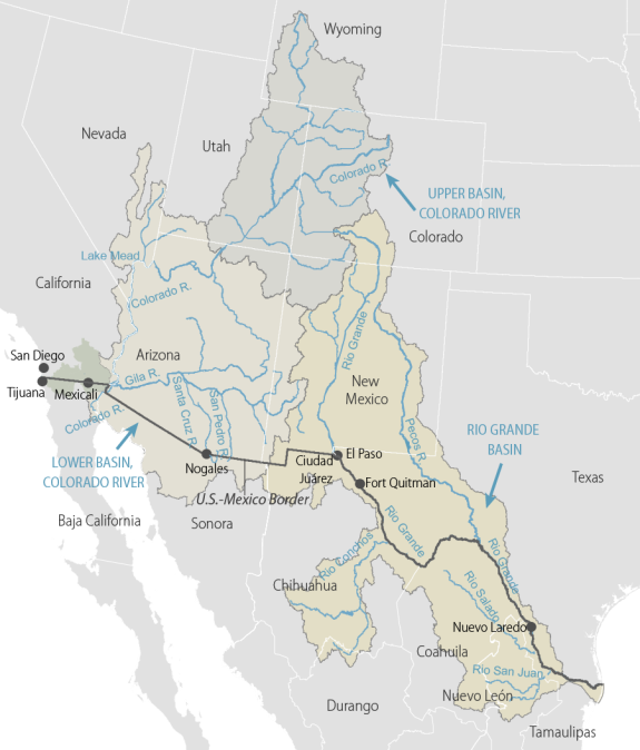
Figure 1. Illustration of the Colorado River and Rio Grande Basins and the Boundaries of U.S.-Mexico Binational River Basins |
 |
|
Source: Congressional Research Service (CRS). Notes: Black line in figure represents the U.S.-Mexico border. Not all tributaries of the Colorado River and Rio Grande are shown or labeled. For more detailed figures, see Figure 2 for the Colorado River basin and Figure 3 for the Rio Grande basin. |
International Boundary and Water Commission and Water-Related Treaties
Evolution of the International Boundary and Water Commission
Beginning with the 1848 Treaty of Guadalupe Hidalgo, which ended the Mexican-American War, the United States and Mexico entered into a series of treaties to establish their official borders.5 The Treaty of Guadalupe Hidalgo identified portions of the Rio Grande and Colorado Rivers as comprising parts of the border.6 In 1889, the United States and Mexico created the International Boundary Commission (IBC) to interpret and apply border agreements.7
In 1895, in light of reports that the United States' westward expansion was creating water shortages,8 Mexico claimed that the United States was violating international law by diverting the Rio Grande excessively.9 Although the U.S. Attorney General opined that the United States had not breached its international obligations,10 the United States agreed to deliver 60,000 acre-feet (AF) of water from the Rio Grande annually to Mexico in exchange for Mexico relinquishing its claims to Rio Grande waters forming the U.S.-Mexico border between El Paso and Fort Quitman, TX (1906 Convention).11 In the 1944 Water Treaty, the United States and Mexico allocated water in the Rio Grande basin below Fort Quitman, TX, and in the Colorado River basin;12 they also authorized the IBC to oversee U.S.-Mexico water-allocation treaties,13 renaming it the IBWC.14
Structure and Role of the International Boundary and Water Commission
Overseeing border demarcation, water allocation administration, and flood control,15 the IBWC regulates sanitary measures and works that the United States and Mexico construct at the U.S.-Mexico border.16 The IBWC consists of U.S. and Mexican Sections, each led by an engineer commissioner, two principal engineers, a legal adviser, and a foreign affairs secretary.17 The U.S. Section of the IBWC (USIBWC) is headquartered in El Paso, TX, and the Mexican Section is located in Ciudad Juárez, Chihuahua.18
The USIBWC is a federal agency, operating under the Department of State's foreign policy guidance.19 The President appoints the USIBWC commissioner,20 the tenure of which has ranged from a few months to 27 years.21 Historically, the position has not been subject to Senate confirmation. The IBWC typically is funded through Annual Department of State, Foreign Operations, and Related Programs appropriations acts.22 Mexico's Ministry of Foreign Affairs oversees the Mexican Section of the IBWC.23
The Minute Process
The 1944 Water Treaty authorizes the IBWC to develop rules and to issue proposed decisions, called minutes, regarding matters related to the treaty's execution and interpretation.24 Once issued, a proposed minute is forwarded within three days to the government of each country for approval.25 If neither country announces its disapproval within 30 days, the minute is considered adopted.26 If either government disapproves, the matter is removed from IBWC control and the two governments negotiate the issue.27 If the two governments reach an agreement, the IBWC must take any further acts "as may be necessary to carry out such agreement."28 The Department of State is the U.S. agency that responds to proposed minutes and negotiates resolutions.29
Minutes adopted pursuant to the 1944 Water Treaty have addressed a range of issues,30 including the operation and maintenance of cross-border sanitation plants,31 water conveyance during droughts,32 dam construction,33 and water salinity problems.34 Because the IBWC also has jurisdiction over certain issues related to binational border treaties, minutes address boundary demarcation matters.35 The 1944 Water Treaty authorizes the executive branch to agree to minutes, which are considered binding executive agreements between the United States and Mexico.36 In consenting to the 1944 Water Treaty, however, the Senate provided that the IBWC and the Secretary of State cannot commit the United States to build works at U.S. expense without Congress's prior approval.37 Accordingly, Congress has passed legislation authorizing construction of public works and projects pursuant to the 1944 Water Treaty.38
Water Delivery Requirements Established in the 1944 Water Treaty
The 1944 Water Treaty defines the basic water-distribution arrangements between the United States and Mexico as
- For the Colorado River basin, the United States provides Mexico with 1.5 million AF of water annually.39
- For the Rio Grande basin below Fort Quitman, TX,
- Mexico and the United States each have a right to one-half of the Rio Grande main channel flow.40
- Mexico has a right to two-thirds of the flows from the Rio Grande's Conchos, San Diego, San Rodrigo, Escondido, and Salado Rivers and the Las Vacas Arroyo tributaries (Mexican Tributaries).41
- The United States has a right to flows from tributaries that feed the Rio Grande in the United States and one-third of the Mexican Tributaries flows,42 which must average at least 350,000 AF per year, measured in five-year cycles.43
If Mexico fails to meet its minimum Rio Grande flow obligations for a five-year cycle because of extraordinary drought—a term not defined in the 1944 Water Treaty or in any minute—it must replace the deficiency during the next five-year cycle.44 Minute 234 established that Mexico may repay a water debt using its Mexican Tributaries water allotment or water stored in international reservoirs,45 such as the Falcon Dam and Amistad Dam,46 located on the Rio Grande on the border of Texas and Mexico.
If Mexico fails to meet its minimum Rio Grande flow obligations for a five-year cycle and the countries dispute that an extraordinary drought existed, Article 24(d) of the 1944 Water Treaty provides certain mechanisms for dispute resolution. First, the IBWC has authority "to settle all differences that may arise between the two Governments with respect to ... application of the Treaty, subject to the approval of the two Governments."47 If the commissioners cannot resolve a dispute, the United States and Mexico address it through diplomatic channels.48 Article 24 also allows the countries to seek recourse through any "general or special agreements which the two Governments have concluded for the settlement of controversies."49
Article 9 of the 1944 Water Treaty provides the IBWC with some flexibility regarding diverting water from the Rio Grande. For example, if an extraordinary drought occurs in one country, the IBWC may permit water to be withdrawn from the other country to help alleviate drought conditions.50 Further, the IBWC may allow one country to use the other's water if this can be accomplished "without injury to the latter and can be replaced at some other point on the river."51 Temporary IBWC-authorized water diversions from one country to another do not establish permanent rights to divert.52 Under Article 9 of the 1944 Water Treaty, the IBWC also maintains records on water belonging to Mexico and the United States.53
The 1944 Water Treaty establishes a hierarchy of preferred water uses: (1) domestic and municipal uses; (2) agriculture and stock raising; (3) electric power; (4) other industrial uses; (5) navigation; (6) fishing and hunting; and (7) any other beneficial uses, which may be determined by the commission.54 Some have critiqued this hierarchy for not providing water for ecological purposes.55 In addition, the 1944 Water Treaty does not expressly establish water quality requirements; it establishes only the water quantity requirements outlined above.56
A protocol accompanying the 1944 Water Treaty establishes that works, such as dams and conveyance structures located wholly in one country and used only partly for treaty compliance, shall be constructed and operated by the federal agencies of that country, consistent with the treaty and in cooperation with the IBWC.57 Subsequent minutes, such as Minute 319 and Minute 323, provide for integrated operations in specific circumstances.58 This report discusses Mexico's reservoir operations and treaty obligations in the "Rio Grande Basin Below Fort Quitman, TX" section below, which focuses on Mexico's Rio Grande water delivery shortfalls.
Other Provisions of the 1944 Water Treaty
In addition to allocating water, the 1944 Water Treaty, among other things, (1) provides for construction of certain dams and channels along the rivers,59 (2) requires the IBWC to establish flood control studies and plans,60 (3) provides for the IBWC to study and plan for hydroelectric energy generation along the rivers,61 and (4) requires the IBWC to regulate maintaining and operating reservoirs.62 These treaty requirements are beyond the scope of this report.
Post-1944 Border Treaties
Although the 1944 Water Treaty empowered the IBWC to issue proposed minutes on treaty interpretation and execution, the United States and Mexico resolved some post-1944 border disputes through new treaties. In 1963, the nations concluded the Chamizal Convention, which resolved a long-standing border dispute relating to weather-related shifts to the Rio Grande's channel at the border of El Paso, TX, and Ciudad Juárez, Chihuahua.63 Although the United States and Mexico agreed to create an international arbitration panel to resolve which nation owned a disputed tract of land—known as the Chamizal tract—that shifted to the north bank of the Rio Grande,64 the United States rejected the arbitration panel's decision.65 The nations eventually resolved the dispute in the Chamizal Convention by relocating the Rio Grande channel and transferring more than 400 acres to Mexico on the south side of the river.66 The Chamizal Convention charged the IBWC with physically relocating the channel and with the "maintenance, preservation, and improvement of the new channel."67 Congress implemented the Chamizal Convention into U.S. law through the American-Mexican Chamizal Convention of 1964.68
The Rio Grande and the Colorado River changed course in other locations during the 20th century, leading to further disputes over sovereignty and land ownership at the border.69 In 1970, the United States and Mexico concluded a treaty (1970 Boundary Treaty) to resolve "all pending boundary differences between the two countries."70 Under this treaty, portions of the Rio Grande and the Colorado River remain international boundaries between the United States and Mexico.71 The treaty also creates mechanisms for the nations and the IBWC to minimize shifts in the boundary rivers' channels and to resolve disputes resulting from such changes.72 Among other things, the 1970 Boundary Treaty prohibits the United States and Mexico from constructing "works" that would deflect or obstruct the normal flow of the rivers. It also requires each nation to remove and pay damages for prohibited works that the IBWC determines have caused "adverse effects" and authorizes the IBWC to recommend improvement projects to stabilize the rivers' channels.73 In addition, the 1970 Boundary Treaty established maritime boundaries in the Gulf of Mexico and the Pacific Ocean.74 Congress implemented the 1970 Boundary Treaty into domestic law through the American-Mexican Boundary Treaty Act of 1972.75
Colorado River Basin
As depicted in Figure 2, the Colorado River and its tributaries flow through seven U.S. states (Arizona, California, Colorado, Nevada, New Mexico, Utah, and Wyoming) and forms the border between the Mexican states of Baja California Norte and Sonora, before emptying into the Gulf of California. Ninety-seven percent of the basin is in the United States. Disputes have occurred over the use of Colorado River water supplies for most of the past century. Although many of these disputes have related to state allocations within the United States, issues also have arisen between the United States and Mexico over water quality, availability, and conservation.
In the first half of the 20th century and when the United States and Mexico were negotiating the 1944 Water Treaty, there were varying estimates of the average volume of flow in the Colorado River. Many of the estimates fell between 16 million AF and 17 million AF annually, although other estimates were higher and lower.76 The U.S. Department of the Interior's Bureau of Reclamation has estimated the long-term average natural flow of the river between 1906 and 2016 at 14.8 million AF.77 At the same time, natural flows from 2000 to 2016 (i.e., during the current ongoing drought) were estimated to be 12.4 million AF.78 Since the 1.5 million AF in flows reaching Mexico generally has been a constant requirement since the 1944 Water Treaty, lower overall flows on the river mean the United States retains less of the river's natural flows than originally estimated.79
In December 2012, the Bureau of Reclamation published a study documenting that the demand for the basin's water in the United States in some years exceeds supply.80 The study projected that the demand-supply imbalance would worsen in coming decades. Although discussion of Colorado River water issues within the United States is beyond the scope of this report, concern about meeting future U.S. demands is significant to discussions about water sharing with Mexico.
The following treaty-implementation issues in the Colorado River basin are discussed in more detail below: salinity, instream flows for environmental restoration, Minute 319, and Minute 323 (which replaced Minute 319).
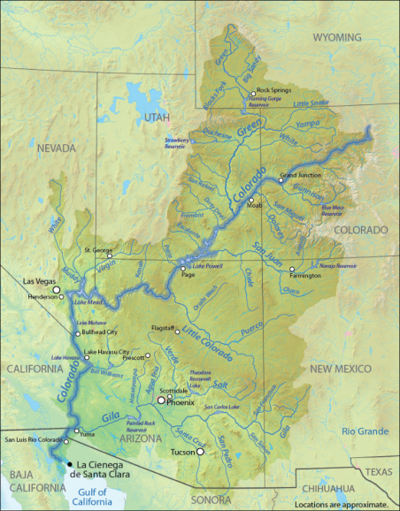 |
|
Source: The Earth Institute at Columbia University, at http://blogs.ei.columbia.edu/wp-content/uploads/2012/12/CO-River-Basin-REVISED.jpg; modified by CRS. |
Salinity
Although the United States has consistently delivered Mexico's annual minimum allotment of Colorado River water, disputes have arisen about the quality of the water. In the 1960s, salinity in the Colorado River rose dramatically. Mexico was receiving water that was too salty for human, livestock, or agricultural uses. The IBWC facilitated agreement by both countries to Minute 218, which took effect in 1965 for a period of five years and required the United States to extend a drainage channel to reduce salinity. Five years later, Mexican farmers remained angry about the salinity issue. After the Mexican government threatened to take the water dispute to the International Court of Justice, the United States agreed to a new minute, Minute 242 (Permanent and Definitive Solution to the International Problem of the Salinity of the Colorado River), in 1973. Per Minute 242, the United States agreed to construct additional channels to control salinity, fund cleanup of the Mexicali Valley lands damaged by the accumulation of salts, and keep salinity levels of delivered water below a certain level.81 Minute 242 remains in force, and the United States continues to comply with its provisions. Although the IBWC-backed resolution to this crisis proved successful, the agreement took a long time and required external pressure.82
Instream Flows for Environmental Restoration
Prior to significant expansion of the basin's water consumption, the Colorado River Delta, at the terminus of the Colorado River, covered 9,650 square miles in the United States and Mexico. The Mexican portion of the delta (where the majority of the delta is located) contains wetlands, woodlands, and desert areas, which are home to many endangered species; part of Mexico's delta is a designated United Nations Biosphere Reserve. Diversion of water resulting in reduced river flows into the delta, conversion of river floodplain to agricultural lands, and groundwater pumping have contributed to the degradation of 90% of the delta's wetlands.83
Environmental advocates recommend that annual flows accompanied by short-duration, high-volume releases (known as pulses or pulse flows) of water every four years would help restore the wetlands.84 These environmental stakeholders have argued that environmental protection should be part of how the United States and Mexico share the river's water. Other stakeholders are less supportive of these restoration efforts. Some are concerned that such efforts may reduce the water available for U.S. users. Others do not want to support these efforts until issues with Mexico's water deliveries in the Rio Grande basin have been addressed (discussed in "Stakeholder Perspectives" of "Rio Grande Basin" section).
The issue of instream flows for environmental protection entered bilateral discussions at the IBWC in the late 1990s. Bilateral discussions in the basin coalesced around improved management of and conservation of both the Colorado River and its delta. Both governments, along with state officials and conservation groups, worked with the IBWC to develop an agreement that would allocate water to Mexico based on whether there was a surplus or a drought and would allow for joint investments to create greater environmental protection, as well as greater water conservation (i.e., ability to store water) for Mexico. These discussions led to Minute 319, which was replaced by Minute 323 in September 2017. Both minutes are discussed below.
Minute 319: Water Conservation and Environmental Restoration
Minute 319 (Interim International Cooperative Measures in the Colorado River Basin through 2017 and Extension of Minute 318 Cooperative Measures to Address the Continued Effects of the April 2010 Earthquake in the Mexicali Valley, Baja California) was signed on November 20, 2012, and was set to expire on December 31, 2017.85 It was replaced by Minute 323 in September 2017. Minute 319 allowed for temporary adjustments to water deliveries to Mexico based on basin drought or surplus water conditions, joint investments to create greater environmental protection, measures to incentivize water conservation, and greater water storage for Mexico in upstream reservoirs. Some viewed Minute 319, when taken together with two prior and related minutes, as recognizing environmental uses as a beneficial use for the basin's treaty waters.86
Key elements of the agreement included the following:
- extending provisions of Minute 318 (Cooperative Measures to Address the Continued Effects of the April 2010 Earthquake in the Mexicali Valley, Baja California) to allow Mexico to defer delivery of its Colorado River water allocation while the country repairs earthquake-damaged infrastructure;
- delivering additional water (i.e., above the 1.5 million AF annual delivery required by the 1944 Water Treaty) to Mexico when water levels are high in Lake Mead;
- reducing deliveries to Mexico during water shortage conditions in the Colorado River basin (i.e., Mexico's annual water deliveries would be reduced if Lake Mead elevations indicated shortage conditions, similar to reduction by the U.S. lower basin states);87
- creating a mechanism by which U.S. water deliveries to Mexico could be held in U.S. reservoirs for subsequent delivery;
- continuing to address salinity concerns per Minute 242; and
- implementing a pilot program of jointly funded water efficiency and conservation projects in Mexico.88
Under the Minute 319 pilot program, stored water was used for a pulse flow from March 23, 2014, to May 18, 2014. The water releases were intended to simulate a spring flood. The high releases meant that, after multiple years of the river not reaching its estuary, the instream flows were sufficient for the river to reconnect with its estuary. The releases and the impacts on instream flow, stream topography, salinity, groundwater, vegetation, birds, and aquatic species were monitored by a binational team of experts. The goal of the pilot program's pulse flow was to improve understanding of water management alternatives for ecosystem restoration.
The IBWC released an interim report providing preliminary results in 2016 based on data through early December 2015.89 The report's interim observations included the following:
- 4,000 acres of the channel and adjacent lands were inundated, resulting in connectivity from the dam to the river's estuary for the first time since 1997;
- bird diversity and abundance improved in the floodplain in 2014 and in 2015;
- active management of riparian sites would be needed for improved restoration of native riparian species; and
- more freshwater would be required to enhance the fish and zooplankton in the upper estuary.90
Under Minutes 318 and 319, Mexico deferred delivery and stored some of its water under the 1944 Water Treaty in Lake Mead.91 According to the then-USIBWC commissioner, Mexico's deferred deliveries added to the volume of water stored in the reservoir (i.e., raised the lake's water elevation).92 Related efforts, including but not limited to actions under Minute 318 and Minute 319, resulted in nearly 10 additional feet of water elevation in Lake Mead at the end of 2016, according to the Bureau of Reclamation, which is the federal agency responsible for operating Lake Mead.93 These water conservation efforts, including the water in storage as a result of Minutes 318 and 319, helped to keep the projected January 1 elevations of Lake Mead higher than 1,075 feet above sea level during the life of the agreements.94 If the projection had shown a water elevation below 1,075 feet, the following would have occurred:
- reductions in Colorado River water deliveries for the lower basin states would have been triggered, and
- reductions in Colorado River water delivered to Mexico pursuant to Minute 319.
In the absence of Minute 319, Mexico would have experienced reductions in the U.S. delivery of Colorado River water only if the extraordinary drought provision for the Colorado River basin in the 1944 Water Treaty had been triggered.95 That is, without Minute 319, the U.S. lower basin states would not have benefited from Mexico sharing in cutbacks during basin shortage conditions unless the extraordinary drought treaty condition had been met. Similarly, without Minute 319, these U.S. states would not have benefited from higher Lake Mead elevations resulting from delayed deliveries by Mexico of its water under the 1944 Water Treaty.96
Minute 323: Extension and Expansion of Cooperative Measures
Minute 323 (Extension of Cooperative Measures and Adoption of a Binational Water Scarcity Contingency Plan in the Colorado River Basin) extends or replaces key elements of Minute 319.97 Minute 323 resulted from more than two years of negotiations among federal and state authorities from both governments, with binational input from water users, scientists, academics, and nongovernmental organizations.
The officials from the two countries signed Minute 323 on September 21, 2017, and it is to be enforced through December 31, 2026. Although Minute 323 is based in part on provisions from Minute 319, Minute 323 also contains additional sections on variability of flows arriving in Mexico and initiates a Binational Water Scarcity Contingency Plan. Minute 323 aims to provide water supply certainty and adequate planning opportunities and is expected to benefit both sides of the border, according to the IBWC.98
Minute 323 established resolutions on the following:
- extending provisions of Minute 319 to deliver additional water to Mexico when water levels are high in Lake Mead;
- extending provisions of Minute 319 to reduce deliveries to Mexico during water shortage conditions in the Colorado River basin, including additional planning, reporting, and coordination measures to reduce future risk to both countries of low elevation in Lake Mead reservoir;99
- establishing a Binational Water Scarcity Contingency Plan, under which each country saves specified volumes of water at certain low reservoir elevations for recovery when reservoir conditions improve;100
- creating Mexico's Water Reserve, whereby U.S. water deliveries to Mexico can be held in U.S. reservoirs in the event of potential emergencies or as a result of water conservation projects in Mexico, to be available for subsequent delivery;
- continuing to address salinity concerns per Minute 242;
- identifying measures related to variability of flows arriving in Mexico;
- providing water and funding for habitat restoration and related monitoring;
- investing in water conservation and new water sources projects to allocate some of the additional water flows for environmental purposes; and
- noting ongoing consultations for design, construction, operation, and maintenance of the All-American Canal, which eventually would need to be addressed in a separate minute.
Minute 323 does not explicitly authorize pulse flows, which were seen most recently in 2014.101 Instead of providing for pulse flows, Minute 323 provides for 210,000 AF of water over the course of the agreement for environmental purposes; the water for environmental purposes is to be provided equally by both countries and a binational coalition of nongovernmental organizations.102 The United States will generate its share of water for the environment solely through its commitment in Minute 323 to contribute $31.5 million over the course of the agreement for water conservation projects in Mexico,103 including $16.5 million anticipated to come from the Bureau of Reclamation. Although these water conservation activities will occur in Mexico, U.S. water agencies will receive a portion of the water generated in return for their monetary contributions, totaling 109,100 AF of water for use in the United States.
Similar to Minutes 318 and 319, Minute 323 will allow Mexico to defer delivery of some of its water under the 1944 Water Treaty and store it in Lake Mead, to be released later for delivery to Mexico.104 The minute extends cooperative measures addressed in Minutes 318 and 319 concerning emergency storage, establishes a revolving account for Mexican water storage in the United States, and provides the opportunity to generate an "Intentionally Created Mexican Allocation" (i.e., a credited pool of Mexican storage) through additional deferred deliveries. Collectively, these components are referred to as Mexico's Water Reserve.
Another major goal of Minute 323 is to establish cooperative efforts to avoid severe water shortages (i.e., amounts in addition to the commitments under Minute 319 that were extended in Minute 323). This aim is seen in the Binational Water Scarcity Contingency Plan, under which each country has committed to save specified volumes of water at certain low reservoir conditions for later use. Mexico would contribute water savings proportionally equivalent to the United States' reductions.105 These measures will occur only if the United States adopts a Lower Basin Drought Contingency Plan (LBDCP).106 According to Minute 323, the plan would be triggered if the projected January 1 Lake Mead elevation (as of the prior August) is at or below 1,090 feet above sea level. As of August 2018, the projection for the Lake Mead elevation in January 2019 was 1,078.9 feet.107 Thus, the projected January 2019 elevation would trigger the Binational Water Scarcity Contingency Plan restrictions if the LBDCP were to be in effect. Although both governments have signed and approved Minute 323, all U.S. basin states and Congress must finalize and approve the LBDCP for the provisions to take full effect.108
Some believe U.S. investment in water conservation in Mexico in exchange for additional water usage will decrease the already-reduced amount of water available for irrigation in Mexico. Others see the Minute 323 efforts to increase water levels in Lake Mead as critical to preventing future water shortages and sustaining cooperation between the two countries.
Rio Grande Basin
Water sharing in two portions of the binational Rio Grande basin has distinct characteristics.
- In the Rio Grande basin between the El Paso-Juárez Valley and Fort Quitman, TX, water sharing is determined in large part by the 1906 Convention. In the El Paso-Juárez Valley, the United States is required to deliver water to Mexico.
- In the Rio Grande basin below Fort Quitman, TX, to the Gulf of Mexico, water sharing is established in large part by the 1944 Water Treaty. In this portion of the basin, Mexico is obligated to deliver water to the United States.
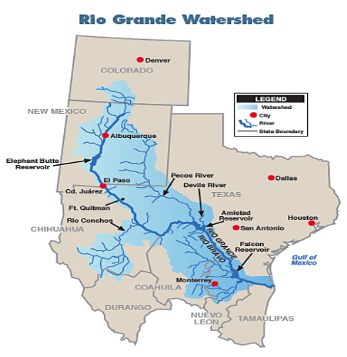
Figure 3 depicts the Rio Grande basin and its tributaries, including the Rio Conchos, which historically is the most significant Rio Grande tributary downstream of Fort Quitman.109
 |
|
Source: Texas Commission on Environmental Quality, Biennial Report to the 85th Legislature (FY2015-FY2016), SFR-57/6, December 2016, at https://www.tceq.texas.gov/assets/public/comm_exec/pubs/sfr/057_16/SFR-057-16-X.pdf. |
Water demands in the Rio Grande basin regularly exceed supply. This imbalance becomes particularly apparent during droughts. Both parts of the Rio Grande basin can experience multiyear droughts (see the drought monitor figures in Appendix B for drought conditions in the basin in September for each of 2011 through 2018). Reduced water availability due to hydrologic conditions and below-target or unpredictable deliveries from Mexico can affect water supplies for the U.S. population and the economy in the U.S. border counties of the Rio Grande. U.S. interests have been particularly concerned by Mexico not meeting its five-year cycle delivery obligations on multiple occasions since 1994.
Dry conditions have contributed to U.S. deliveries to Mexico in the El Paso-Juárez Valley falling below the 60,000 AF annual requirement established by the 1906 Convention for six of the seven years from 2012 to 2018.110 Since the start of the current five-year cycle for the Rio Grande below Fort Quitman, TX, in October 2015, the role that dry conditions have had in shaping Mexico's deliveries is less clear. In the first year of the cycle, Mexico fell 15% below its water-delivery obligations under the 1944 Water Treaty. In the second year of the cycle, Mexico made up its deficit and exceeded the cumulative target for the first two years. The third year of the five-year cycle ended in October 2018.111 IBWC indicates that Mexico delivered to the United States less than 350,000 AF in the third year of the cycle. However, Mexico's higher deliveries in the second year resulted in cumulative deliveries for the first three years of the cycle being almost 98% of the three-year delivery target of 1.05 million AF.
In recent years, Congress has engaged in Rio Grande water issues by increasing its oversight of water deliveries, principally by requiring periodic reporting by the Department of State.112 As part of its broader effort to improve the reliability in Mexico's water deliveries, the IBWC is developing a binational model for water management in the Rio Grande.113 Recent water deliveries in the two portions of the Rio Grande basin and related issues, including congressional and diplomatic efforts, are discussed in more detail below.
Rio Grande Basin to Fort Quitman, TX
Under the 1906 Convention, which guides U.S. deliveries to Mexico at Ciudad Juárez, the United States is to deliver annually to Mexico 60,000 AF (enough water to irrigate about 25,000 acres) for use in the Juárez Valley of Chihuahua.114 During conditions of extraordinary drought, these deliveries to Mexico are reduced proportionally to reductions in available supplies in the broader basin.115 U.S. deliveries to Mexico have been reduced in roughly 30% of the years since the convention came into force. The United States is not required to repay any reduced deliveries. Table 1 shows U.S. deliveries to Mexico in recent years falling below the 60,000 AF annual requirement established by the 1906 Convention for six of the seven years from 2012 to 2018.116
|
Year |
Acre-Feet (AF) |
% of Full Allocation |
|
2012 2013 2014 2015 2016 2017 2018 |
23,200 3,700 18,300 33,800 46,800 60,000 37,700 |
39% 6% 31% 56% 78% 100% 63% |
Source: CRS using annual delivered amounts provided to CRS from Bureau of Reclamation (Email from Bureau of Reclamation to CRS, August 10, 2018).
In some years, U.S. water deliveries to Mexico in the El Paso-Juárez Valley have drawn attention from U.S. water users.117 The portion of the Rio Grande that traverses New Mexico at times has experienced particularly low flow and reservoir storage due to drought. When water stored in project reservoirs is low, Rio Grande Project water users have seen significant curtailment in their water deliveries.118 The Rio Grande Project is a Bureau of Reclamation project that furnishes irrigation water for approximately 178,000 acres in New Mexico and Texas. Data from Table 1 and data provided to the Congressional Research Service by the Bureau of Reclamation show that the amount delivered to Mexico represented on average around 9% of the amount allocated to the principal U.S. irrigation districts for the Rio Grande Project from 2012 to 2018.119
Hydrologic changes in the Rio Grande in New Mexico and at the border, specifically climate conditions that can alter water availability and seasonal streamflow, could further complicate water delivery to U.S. water users and to Mexico and could exacerbate seasonal deficits for users and for riverine ecosystems and species.120 One assessment of conditions in the mountainous headwaters of the Rio Grande basin from 1958 to 2015 identified that winter and springtime temperatures have increased and peak snowpack has declined, contributing to the runoff from melting snowpack and post-snow rainfall occurring earlier in the spring and to diminished flows in late spring and summer months.121
A topic of disagreement between Texas stakeholders and the IBWC has been whether half or all of the water reaching Fort Quitman, TX, is allocated to the United States under the binational agreements. According to Article 4 of the 1944 Treaty, Mexico and the United States each have right to one-half of the Rio Grande main channel flow between Fort Quitman and the lowest major international storage dam unless otherwise allocated. Since 1958, the IBWC has allocated half of the water that reaches Fort Quitman to Mexico and half to the United States.122 IBWC uses the resulting water volumes when tabulating each country's allocation pursuant to the 1944 Water Treaty. Estimates place the cumulative total allocated to Mexico at Fort Quitman around 2.1 million AF from 1958 to 2016.123
The Texas Commission for Environmental Quality (TCEQ) and others argue against how IBWC allocates the water in the river segment that forms the U.S.-Mexico border between El Paso and Fort Quitman. Their argument is that Mexico in the 1906 Convention waived its rights to the Rio Grande waters arriving in Fort Quitman and that the division of the waters of the Rio Grande by the 1944 Water Treaty begins below Fort Quitman.124 Under the TCEQ's interpretation, the United States is entitled to 100% of the Rio Grande water in this segment of the river.125 In 2013, the USIBWC disputed this interpretation. It asserted that the 1944 Water Treaty intended to divide equally all Rio Grande waters beginning in Fort Quitman, including those waters arriving at Fort Quitman.126 In support of its position, the USIBWC cited historical IBWC practice, as reflected in the minutes to the 1944 Water Treaty, and statements made to the Senate Committee on Foreign Relations during consideration of the 1944 Water Treaty.127
Rio Grande Basin Below Fort Quitman, TX
The 1944 Water Treaty requires Mexico to deliver to the United States portions of the water in several tributaries that flow into the Rio Grande basin below Fort Quitman, TX.128 The treaty specifically states the following:
To the United States ... (b) One-third of the flow reaching the channel of the Rio Grande (Rio Bravo) from the Conchos, San Diego, San Rodrigo, Escondido and Salado Rivers and the Las Vacas Arroyo, provided that this third shall not be less, as an average amount in cycles of five consecutive years, than 350,000 acre-feet (431,721,000 cubic meters) annually.129
The IBWC accounts for Mexico's deliveries to the United States pursuant to the 1944 Water Treaty largely by aggregating deliveries (i.e., 1.75 million AF) over a five-year cycle, with an annual average delivery target of 350,000 AF. The cycles are typically five years long but may be shortened if certain reservoirs are filled with waters belonging to the United States.130 Once implementation of the 1944 Water Treaty began, Mexico met its deliveries within the five-year cycles until the 1994-2003 drought.131 Mexico has not met its obligations at the conclusion of the following four five-year cycles: 1992-1997, 1997-2002, 2002-2007, and 2010-2015.132
Various factors may have contributed to Mexico not meeting delivery obligations under the 1944 Water Treaty, including the over-allocation of the water and the effect of extended drought conditions.133 Over-allocation persists in both the Mexican and the U.S. portions of the basin.134 A 2011 academic assessment of the treaty's performance found that under drought conditions, the water-sharing system established by the 1944 Water Treaty did not recover as fast as expected (i.e., Mexico's water deficits lasted longer than anticipated) and the deficits that occurred were larger in volume than estimated.135
Mexico's Rio Grande Deliveries: 2010-2015 Cycle and 2015-2020 Cycle
A delivery cycle started October 25, 2010, and ended October 24, 2015. Final accounting for the 2010-2015 cycle indicated a shortfall of 15% (263,250 AF) in Mexico's water deliveries.136 The deficit largely resulted from low deliveries early in the cycle.137 By January 25, 2016, Mexico had paid off the debt from the previous cycle, while simultaneously making deliveries under the current cycle.138 Mexico paid off the remaining 263,250 AF through a combination of transferring water stored behind Amistad Dam and providing for a period 100% of the water from three of Mexico's treaty tributaries.
The current cycle began in October 2015 and is anticipated to end in October 2020, unless the cycle ends early.139 During the current cycle, Mexico's deliveries were below 350,000 AF in the first year; that is, the first year of the 2015-2020 cycle ended with Mexico delivering 216,562 AF, which was 133,439 AF below the annual target delivery. During the second year of the cycle, Mexico's deliveries exceeded the cumulative two-year target of 700,000 AF. The combined amount delivered in the first and second years of the current cycle was almost 800,000 AF. Mexico accomplished this in part by using flexibility provided by Minute 234 to allow for 50% of the water from some of its Rio Grande tributaries to be counted toward its deliveries rather than 33%, as stipulated in the 1944 Water Treaty.140
Stakeholder Perspectives
The predictability and consistency of Mexico's deliveries within the five-year cycle is a point of tension among some basin interests. This tension was particularly acute during 2012, when Texas water-rights holders faced persistent dry conditions and Mexico delivered significantly less water than the annual delivery target. Two binational reservoirs on the Rio Grande at Amistad Dam and Falcon Dam store much of the water that Mexico delivers to the United States. The storage and releases from these reservoirs help to regulate the timing of when the water is available for U.S. interests. Some U.S. stakeholders have argued that the uncertainty regarding the timing of Mexico's deliveries reduces the effective use and management of the delivered water, its storage, and its release. Mexico, by contrast, has argued that its deliveries comply with the cycle provided for in the 1944 Water Treaty.
Some U.S. interests, particularly agricultural water users in Texas, have contended that Mexico's pattern of water delivery treats U.S. deliveries as a secondary priority to meeting Mexico's own water uses. These stakeholders see Mexico's use of wet-weather flows (e.g., excess flows after large storms) as reducing the reliability of U.S. water supplies from Rio Grande. The flexible five-year cycle for Mexico's Rio Grande deliveries at times is a frustration for U.S. water users in part because of the contrast with the more prescriptive nature of the U.S. water-delivery requirement to Mexico in the Colorado River (i.e., specified quantities are required to be delivered annually). Some interests have raised the possibility of renegotiating the 1944 Water Treaty.141
Other basin stakeholders have argued that the 1944 Water Treaty purposefully provided flexibility in the timing of Mexico's deliveries to account for the annual variability of water conditions in the basin. Whereas some stakeholders view the flexibility in delivery schedule as generous to Mexico, some Mexican interests view the water delivery requirements in the 1944 Water Treaty as generous to the United States.
Congressional Responses
Several Members of Congress noted the complaints of Texas farmers, local officials, and state officials about Mexico's water deliveries.142 Some Members of Congress expressed concerns about the adequacy of the efforts by the USIBWC and the U.S. Department of State to press Mexico to comply more consistently with its 1944 Water Treaty obligations. This attention has resulted in various congressional requirements for the U.S. Department of State to report on the Rio Grande; these requirements have appeared in law and been included in congressional reports accompanying enacted legislation.143
Since 2014, Congress has directed the Department of State to report to Congress on the Rio Grande. In the 2014 farm bill (Section 12310 of Agriculture Act of 2013; P.L. 113-79), Congress enacted a requirement for an annual report on efforts by Mexico to meet its Rio Grande treaty.144 Beginning with bill text for the FY2015 Department of State appropriations and subsequently in congressional reports accompanying appropriations bills, appropriators have regularly included direction for other reports on Mexico's Rio Grande water deliveries. For more on these reporting requirements, see Appendix A. The reporting requirements are for report delivery directly to Congress and congressional committees; only limited information about these reports and their contents has been publicly available.
Diplomatic and Technical Responses
In addition to the U.S. and Mexican Sections of the IBWC discussing Mexico's water deliveries, other U.S. and Mexican political officials have engaged to address water-sharing concerns.145 Reported outcomes of diplomatic efforts since 2010 include the following:
- the Mexican government initiated some releases from a reservoir on the San Rodrigo River in spring 2013,146 and
- the two countries exchanged technical data to assist in developing options for future water management in the basin, including a July 2015 binational meeting on basin water modeling efforts and various means to improve the predictability and compliance of Mexico's water deliveries.
IBWC continues to work toward a binational model for the Rio Grande.147 This modeling effort is assisted by investments made since 2016 in equipment for improved monitoring of the Rio Grande (e.g., acoustic measurements to calculate flow).148 Such modeling efforts may identify opportunities to shift from deliveries that at times are dominated by wet-weather flows to more proactive management in the basin to improve the predictability and reliability of water deliveries to the United States.
IBWC has used binational working groups in its efforts to advance binational dealings on water and environmental management issues in the Colorado River, and it is now applying the approach in the Rio Grande.149 That is, IBWC has developed binational working groups related to policy and hydrology for the Rio Grande with the objective of using science to develop better operational policy that ensures compliance with the 1944 Water Treaty and improves predictability and reliability in water deliveries for both countries.150 The hydrology work group is to consider data, modeling, and operations to address treaty compliance; the policy group will address treaty compliance actions.151 The State of Texas and Mexico's CONAGUA (Mexico's national water commission) serve as technical advisers to the work groups.152
Next Steps and Remaining and Emerging Topics
As the IBWC Rio Grande working groups and modeling efforts advance, they may identify opportunities for improving the predictability and reliability of Mexico's water deliveries to the United States. A next step may be to assess the extent of binational support for more proactive management of water deliveries. Some interests in the basin may want to tie advancements in water management to advancements in the river's water quality and ecological health.
In addition to the persistent questions related to the definition of extraordinary drought and other terms of the 1944 Water Treaty, there are unresolved questions related to Minute 234.153 Minute 234, established in 1969, includes a procedure whereby Mexico may pay a water debt in the Rio Grande using three different sources of water. Minute 234 requires that deficit payments from these three sources be made concurrently with required deliveries in the following five-year cycle. The United States and Mexico differ in their interpretation and implementation of Minute 234. For example, Mexico claimed that in the event of extraordinary drought, only the deficit incurred during the 1992-1997 five-year water cycle needed to be repaid in the following five-year cycle (i.e., by 2002) and that any deficit incurred during the 1997-2002 cycle could be deferred until the next five-year cycle. The United States argued that Minute 234 required Mexico to make up the water debt incurred during the 1997-2002 cycle concurrently with the 1992-1997 water debt. The disagreement over the interpretation of Minute 234 remains unresolved. Differences of interpretation related to Minute 234, extraordinary drought, or other matters are particularly likely to arise during dry conditions and when Mexico's Rio Grande deliveries fall below annual targets and five-year cycle requirements.
Unconventional oil and gas development in northeastern Mexico could represent an emerging water use in the Rio Grande basin that influences how Mexico uses and manages water in its portion of the basin. The use of water for hydraulic fracturing as well as the disposal of wastewaters from oil and gas development may draw attention to border water quality protections and monitoring.
Outlook for Binational Water Sharing
Congress has maintained significant interest in Mexico. To date, Congress has been involved in binational water-sharing issues primarily through oversight.
The tone and nature of binational water relations between the United States and Mexico depend in part on the effectiveness of efforts to resolve water tensions and improve cooperative management of shared rivers. Binational water relations and the work of the IBWC also may be shaped by the broader U.S.-Mexico relationship. This broader relationship is determined by many issues such as trade, immigration, and efforts to enhance border security, including construction of a border wall or fencing. Some observers have raised questions about the IBWC's role in addressing flooding and floodplain concerns that may arise with some segments of a border wall or border fencing.154
Other factors that may shape future water sharing include basin hydrologic conditions, the population's water demand, and economic activity of the basins. Input on water sharing from and actions of the U.S. Department of State, Mexico's Ministry of Foreign Affairs, and executive branch leaders in both countries also may shape how the IBWC addresses tensions and seeks opportunities for cooperation and improved management.
As this report discusses, various issues may shape binational water sharing and IBWC activities in the coming years. For the Colorado River basin, hydrologic conditions and the U.S. lower basin states' adoption of a drought contingency plan may shape what occurs pursuant to Minute 323. For Congress, binational Colorado River oversight topics may encompass Minute 323 implementation and operations and deliveries during shortage conditions. For the Rio Grande, Mexico has not met its 1944 Water Treaty deliver obligations at the conclusion of four recent five-year cycles. The IBWC is working to identify opportunities for improving the predictability and reliability of Mexico's water deliveries to the United States.
Appendix A. Congressional Reporting Requirements Related to the Rio Grande
Pursuant to the reporting requirements discussed below, the U.S Department of State has delivered reports to various committees of Congress, including as recently as March 2018. The reporting requirements are for report delivery directly to Congress and congressional committees; only limited information about these reports and their contents has been publicly available.
Ongoing Reporting Requirements
Since 2014, Congress has asked the U.S. Department of State to annually report to Congress on Mexico's Rio Grande water deliveries. The 2014 farm bill (Agriculture Act of 2013; P.L. 113-79) included the following requirement in Section 12310:
Not later than 120 days after the date of the enactment of this Act and annually thereafter, the Secretary of State shall submit to Congress a report on efforts by Mexico to meet its treaty deliveries of water to the Rio Grande in accordance with the Treaty between the United States and Mexico Respecting Utilization of waters of the Colorado and Tijuana Rivers and of the Rio Grande (done at Washington, February 3, 1944).155
This reporting requirement has no explicit end date; that is, the 2014 farm bill reporting requirement remains in effect.
Reporting Requirements in Annual Appropriations Bills and Accompanying Reports
Water Delivery Reporting Requirements
Beginning with statutory provisions for FY2015, appropriators have regularly included direction in congressional reports accompanying appropriations bills for the U.S. Department of State. The direction is for a report on Mexico's water deliveries to the United States in the Rio Grande. On December 16, 2014, Section 7045(g)(3) of Division J of P.L. 113-235—the Consolidated and Further Continuing Appropriations Act of 2015—was enacted. It required that the Secretary of State report to the Committees on Appropriations on the following water delivery and accounting issues:
Not later than 45 days after the enactment of this Act, the Secretary of State, in consultation with the Commissioner for the United States Section of the International Boundary and Water Commission (IBWC), shall report to the Committees on Appropriations on the efforts to work with the Mexico Section of the IBWC and the Government of Mexico to establish mechanisms to improve the transparency of data on, and predictability of, the water deliveries from Mexico to the United States to meet annual water apportionments to the Rio Grande, in accordance with the 1944 Treaty between the United States and Mexico Respecting Utilization of Waters of the Colorado and Tijuana Rivers and of the Rio Grande, and on actions taken to minimize or eliminate the water deficits owed to the United States in the current 5-year cycle by the end of such cycle: Provided, That such report shall include a projection of the balance of the water delivery deficit at the end of the current 5-year cycle, as well as the estimated impact to the United States of a negative delivery balance.156
The joint explanatory statement for the FY2016 Consolidated Appropriations Act (Division K, P.L. 114-113) carried forward reporting requirements from P.L. 113-235 related to Mexico's water deliveries. For FY2017 and FY2018, S.Rept. 114-290 and S.Rept. 115-152 continued similar reporting requirements. For FY2018, H.Rept. 115-253 also included the following direction from the House Appropriations Subcommittee on State, Foreign Operations, and Related Programs:
The Committee notes the treaty obligations of Mexico to supply water deliveries to the Rio Grande and recognizes the importance of transparency concerning such matters. The Committee directs International Boundary and Water Commission (IBWC) to regularly publish water delivery data on its Web site, including projections for the balance of water deliveries. The Committee expects IBWC to hold quarterly meetings with interested stakeholders to inform them of IBWC activities and receive feedback.157
Some annual appropriations-related reporting requirements also may continue in FY2019. The 115th Congress is considering various bills with accompanying reports that include references to reporting on Rio Grande water topics. For example, the Senate report for FY2019 Department of State appropriations—S.Rept. 115-282 accompanying S. 3108—would continue the reporting requirement.158 The House report for FY2019 appropriations—H.Rept. 115-829 for H.R. 6538—would continue report language requiring the publishing of data and the holding of stakeholder meetings, similar to H.Rept. 115-253.
Other Rio Grande Reporting
H.Rept. 115-253 also includes the following language related to flood control rehabilitation:
The Committee recommendation includes not less than the request for the Rio Grande Flood Control System Rehabilitation Project to continue and maintain levee projects along the Rio Grande, including environmental, hydrologic, hydraulic, and low water weir studies along the Rio Grande Valley that are consistent with the projects outlined within the Mexican Water Treaty of 1944, Treaty Series 994.159
H.Rept. 115-829 would continue the above language and add the following from the House Appropriations Subcommittee on State, Foreign Operations, and Related Programs: "The Committee also supports efforts to reduce the amount of sediment and other activities to maintain the health of the river."
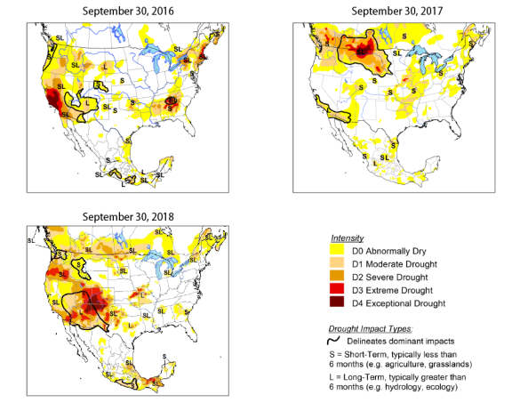
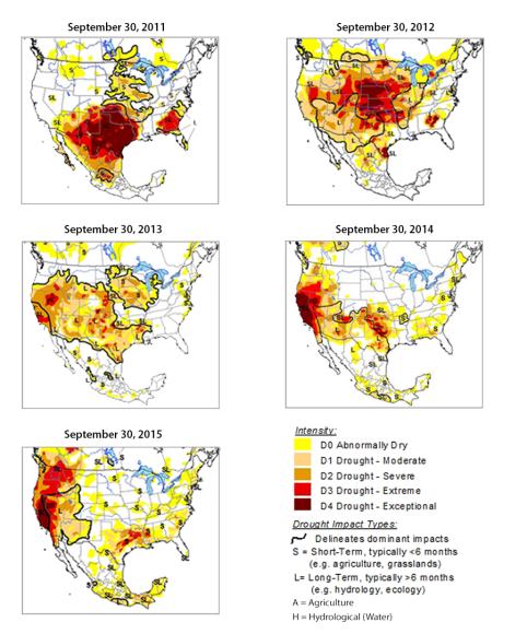
Water sharing becomes more complicated during droughts, and both the Colorado River and the Rio Grande basins are prone to multiyear droughts. The North American Drought Monitor provides maps that synthesize various drought indexes and impacts. Experts from the United States, Mexico, and Canada create these maps. Figure B-1 shows the drought monitor in September 2016, September 2017, and September 2018. For September 2018, extreme and exceptional drought conditions existed in the headwaters of the Rio Grande, and drought conditions of varying degrees in most of the Colorado River basin. Figure B-2 shows the evolution of drought conditions from September 2011 through September 2015. For the Rio Grande, as shown in Figure B-2, both 2011 and 2012 were marked by dry conditions, resulting from high heat, low precipitation, and low runoff throughout most of the basin. For the Colorado River, dry conditions in the basin developed in 2012, persisted in varying degrees through October 2016, and prominently returned in 2018.160
|
Figure B-1. Drought Monitor for September 2016 through September 2018 |
 |
|
Source: North American Drought Monitor maps (minor modifications by CRS), available at http://www.ncdc.noaa.gov/temp-and-precip/drought/nadm/index.php. |
|
Figure B-2. Evolution of North American Drought from 2011 to 2015 |
 |
|
Source: North American Drought Monitor maps (minor modifications by CRS), available at http://www.ncdc.noaa.gov/temp-and-precip/drought/nadm/index.php. |
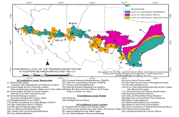
Appendix C. U.S.-Mexican Transboundary Aquifers
Binational aquifers are transboundary water resources that can be particularly important for meeting needs during dry times. In some parts of the border, binational aquifers are significant sources of domestic water supply for overlying populations. For example, the Hueco Bolson aquifer provides water for the 1.5 million residents of Ciudad Juárez and for 40% of the 730,000 residents of El Paso, TX. Over the last century, many border aquifers have declined in volume and/or quality. No broad bilateral agreement exists on U.S.-Mexican border groundwater management and use.161
Declining water levels, deteriorating water quality, and increasing use of groundwater resources have raised concerns about the long-term availability of the border's groundwater. Knowledge about the extent, depletion rates, and quality of transboundary aquifers is limited, and in some areas extremely limited. A 2016 study entitled "Identifying and Characterizing Transboundary Aquifers Along the Mexico-U.S. Border: An Initial Assessment" identified 36 aquifers along the U.S.-Mexican border, as shown in Figure C-1.162
As the level of water in an aquifer falls, surface water flows can decline. For example, historically, the Hueco Bolson aquifer was recharged primarily by precipitation and the aquifer contributed to the flow of the Rio Grande (i.e., the Rio Grande gained water from the aquifer). However, as the aquifer's level declined due to pumping levels exceeding recharge rates, the river-aquifer flows reversed. The Rio Grande began to recharge the aquifer, resulting in diminished surface water flows; that is, the river became a losing stream in the reach of the Hueco Bolson, as surface water entered the Hueco Bolson aquifer.
A binational aquifer quantity and quality assessment program has been initiated, pursuant to the U.S.-Mexican Transboundary Aquifer Assessment Act (P.L. 109-448; 42 U.S.C. §1962 note);163 the legislation identified four border aquifers as priorities for study. The act authorized the Secretary of the Interior, through the U.S. Geological Survey, to collaborate with the states of Arizona, New Mexico, and Texas through their Water Resources Research Institutes and with the International Boundary and Water Commission, stakeholders, and Mexican counterparts to provide information and a scientific foundation for state and local officials to address pressing challenges along the U.S.-Mexican border. According to the act's accompanying Senate report (S.Rept. 109-17),
Ground-water pumping has lowered the water table, depleted aquifers, and reduced the base flow of many streams thus decreasing the quantity of water available to support critical riparian habitats. Excessive groundwater pumping in some major urban centers, such as in the El Paso/Juárez metropolitan region, has caused land subsidence that has damaged homes and essential urban infrastructure. In addition to the effects of ground- and surface-water depletion, degradation of water quality has reduced habitat suitability for the region's diverse biota.
Both U.S. and Mexican entities fund the aquifer assessment program. After multiple years of no U.S. federal funding, federal funds for the assessments resumed in FY2016, with $1 million provided; an additional $1 million in federal funding was provided in each of FY2017 and FY2018.164 Before the resumption of federal funding in FY2016, federal funding had totaled $2 million and had last been provided in FY2010. In November 2016, a binational study of the San Pedro aquifer, located along a portion of the Arizona-Sonora border, was released. The study identified available data and data gaps. It noted that discharges from the aquifer into the San Pedro River are in decline, with climate cycles and pumping likely contributing to the decline.165 Activities planned in 2018 include continued development of the report and database on the Santa Cruz aquifer (to the west of the San Pedro aquifer) and additional research on saline-water topics associated with the two freshwater aquifers near El Paso.166
Author Contact Information
Footnotes
| 1. |
In Mexico, the Rio Grande also is known as the Río Bravo del Norte. |
| 2. |
Treaty Between the United States of America and Mexico Respecting Utilization of Waters of the Colorado and Tijuana Rivers and of the Rio Grande, U.S.-Mex., February 3, 1944, 59 Stat. 1219, at https://www.ibwc.gov/Files/1944Treaty.pdf (hereinafter 1944 Water Treaty). |
| 3. |
For more on the congressionally required reporting, see the section of this report titled "Congressional Responses" and Appendix A. |
| 4. |
Although U.S.-Mexican treaties generally do not address water in aquifers, groundwater is a significant source of water for some border communities, especially during dry conditions. For more on shared groundwater, see Appendix C. |
| 5. |
See Treaty of Peace, Friendship, Limits, and Settlement with the Republic of Mexico, U.S.-Mex., February 2, 1848, 9 Stat. 922, at http://www.ibwc.state.gov/Files/Treaty_of_1848.pdf (hereinafter Treaty of Guadalupe Hidalgo); Convention Between the United States of America and the United States of Mexico Providing for an International Boundary Survey to Relocate the Existing Frontier Line Between the Two Countries West of the Rio Grande, U.S.-Mex., July 29, 1882, 22 Stat. 986, at https://www.ibwc.gov/Files/TREATY_OF_1882.pdf (hereinafter 1882 Boundary Convention); Convention Between the United States of America and the United States of Mexico to Facilitate the Carrying Out of the Principles Contained in the Treaty of November 12, 1884, and to Avoid the Difficulties Occasioned by Reason of the Changes Which Take Place in the Bed of the Rio Grande and That of the Colorado River, U.S.-Mex., March 1, 1889, 26 Stat. 1512, at http://www.ibwc.state.gov/Files/TREATY_OF_1889.pdf (hereinafter 1889 Boundary Convention). |
| 6. |
Treaty of Guadalupe Hidalgo, Article 5. |
| 7. |
See 1889 Boundary Convention. In 1882, the United States and Mexico created the International Boundary Commission (IBC) as a temporary boundary-setting body. See 1882 Boundary Convention, Article 3. The United States and Mexico reestablished the IBC in 1889 and made it permanent in 1900. See Convention Between the United States of American and the United States of Mexico, Extending for an Indefinite Period the Treaty of March 1, 1889, Between the Two Governments, Known as the Water Boundary Convention, U.S.-Mex., Nov. 21, 1900, 31 Stat. 1936. |
| 8. |
Natural Resources Committee, "Part VI - The Rio Grande Joint Investigation in the Upper Rio Grande Basin in Colorado, New Mexico, and Texas, 1936-1937," in Regional Planning (U.S. Government Publishing Office, 1938), p. 7, at https://archive.org/download/regionalplanning1938riogranderich/regionalplanning1938riogranderich.pdf/. |
| 9. |
See Letter from M. Romero, Foreign Minister, United Mexican States, to Richard Olney, United States Secretary of State, October 21, 1895, reprinted in S. Doc. No. 57-154, at 179. |
| 10. |
Treaty of Guadalupe Hidalgo—International Law, 21 Op. Atty. Gen. 274, 283 (1895). |
| 11. |
See Convention Between the United States and Mexico Providing for the Equitable Distribution of the Waters of the Rio Grande for Irrigation Purposes, May 21, 1906, U.S.-Mex. 34 Stat. 2953 (hereinafter Convention of 1906). An acre-foot is approximately 326,000 gallons of water, enough to cover an acre of land with one foot of water. See "The Colorado River and Hoover Dam," U.S. Department of the Interior, Bureau of Reclamation, updated February 7, 2017, at https://www.usbr.gov/lc/region/pao/faq.html. |
| 12. |
Convention of 1906. |
| 13. |
Convention of 1906. Article 2 states the following: "The application of the present Treaty, the regulation and exercise of the rights and obligations which the two Governments assume thereunder, and the settlement of all disputes to which its observance and execution may give rise are hereby entrusted to the International Boundary and Water Commission." |
| 14. |
Convention of 1906. |
| 15. |
Article 3 of the 1944 Water Treaty also lists various other joint uses of international waters that the International Boundary and Water Commission (IBWC) may address, including the following: domestic, agricultural, electrical and industrial uses, navigation, fishing, and hunting. 1944 Water Treaty, Article 3. |
| 16. |
1944 Water Treaty, Article 3. |
| 17. |
Convention of 1906. IBWC members have diplomatic status, enjoy "the privileges and immunities appertaining to diplomatic officers," and may "freely carry out their observations, studies and field work in the territory of either country." Works and structures that are wholly located within one country—despite their potential international character—remain under the exclusive jurisdiction of the country in which they are located and that country is responsible for the associated expenses. |
| 18. |
IBWC, "The International Boundary and Water Commission—Its Mission, Organization and Procedures for Solution of Boundary and Water Problems," accessed October 2, 2018, at http://www.ibwc.state.gov/About_Us/About_Us.html (hereinafter IBWC Mission). |
| 19. |
IBWC Mission. |
| 20. |
See 1889 Boundary Convention, Article 2. |
| 21. |
"History of U.S. Section Commissioners," IBWC, accessed October 1, 2018, at https://www.ibwc.gov/About_Us/Commish_History.html. |
| 22. |
See, for example, P.L. 113-234, Div. J, Title I, 128 Stat. 2130, 2579. |
| 23. |
See IBWC Mission. |
| 24. |
1944 Water Treaty, Article 25. The term minutes in this context originally was derived from the more traditional use of the term, meaning notes used to memorialize a meeting between the representatives of the two governments. See Robert J. McCarthy, "Executive Authority, Adaptive Treaty Interpretation, and the International Boundary and Water Commission, U.S.-Mexico," University of Denver Water Law Review 197 (2011), pp. 217-218. The term eventually evolved to mean a proposed decision issued by the IBWC pursuant to the 1944 Water Treaty. |
| 25. |
1944 Water Treaty, Article 25. |
| 26. |
1944 Water Treaty, Article 25. |
| 27. |
1944 Water Treaty, Article 25. |
| 28. |
1944 Water Treaty, Article 25. |
| 29. |
1944 Water Treaty, Article 2. |
| 30. |
For a collection of the IBWC's minutes, see "Minutes Between the United States and Mexican Sections of the IBWC," IBWC, accessed October 2, 2018, at http://www.ibwc.gov/Treaties_Minutes/Minutes.html. |
| 31. |
IBWC Minute 206, January 13, 1958. |
| 32. |
IBWC Minute 307, March 16, 2001. |
| 33. |
IBWC Minute 182, September 23, 1946. |
| 34. |
IBWC, Minute 242, August 30, 1973; Agreement Confirming Minute No. 242 of the International Boundary and Water Commission, U.S.-Mex., August 30, 1973, 24 U.S.T. 1968, 1971. |
| 35. |
For example, IBWC Minute 324, April 10, 2018. |
| 36. |
For background on international agreements, see CRS Report RL32528, International Law and Agreements: Their Effect upon U.S. Law, by [author name scrubbed]. For a discussion of the legal status of minutes under the 1944 Water Treaty, see Robert Jerome Glennon and Peter W. Culp, "The Last Green Lagoon: How and Why the Bush Administration Should Save the Colorado River," Ecology Law Quarterly 903 (2002), pp. 981-984. |
| 37. |
Congressional Record, 79th Cong., 1st Sess., 1945, vol. 91, pt. 3:3492. |
| 38. |
See 22 U.S.C. §§277a et seq. |
| 39. |
1944 Water Treaty, Article 10. |
| 40. |
1944 Water Treaty, Article 4. |
| 41. |
1944 Water Treaty, Article 4(A)(c). |
| 42. |
1944 Water Treaty, Article 4(B). |
| 43. |
1944 Water Treaty, Article 4(B)(c). |
| 44. |
1944 Water Treaty, Article 4. For more on compliance, see Allie Alexis Umoff, "An Analysis of the 1944 U.S.-Mexico Water Treaty: Its Past, Present, and Future," Environs: U.C. Davis School of Law Environmental Law and Policy Journal, vol. 32, no. 1 (2008) (hereinafter Umoff 2008). |
| 45. |
IBWC Minute 234, December 2, 1969. |
| 46. |
IBWC, "Falcon Dam & Power Plant," accessed January 24, 2017, at http://www.ibwc.state.gov/Organization/Operations/Field_Offices/Falcon.html. IBWC, "Amistad Dam and Power Plant, Del Rio, Texas," accessed January 24, 2017, at http://www.ibwc.state.gov/Organization/Operations/Field_Offices/amistad.html. |
| 47. |
1944 Water Treaty, Article 24(d). |
| 48. |
1944 Water Treaty. |
| 49. |
1944 Water Treaty. |
| 50. |
1944 Water Treaty, Article 9(f). |
| 51. |
1944 Water Treaty, Article 9(d). |
| 52. |
1944 Water Treaty, Article 9(e). |
| 53. |
1944 Water Treaty, Article 9(j). |
| 54. |
1944 Water Treaty, Article 3. |
| 55. |
See, for example, Umoff 2008. |
| 56. |
See 1944 Water Treaty. |
| 57. |
The protocol states that for construction or use of works for storage or conveyance of water, flood control, stream gaging, or for any other purpose, which are situated wholly within the territory of the country of that Section, and which are to be used only partly for the performance of treaty provisions, such jurisdiction shall be exercised, and such functions, including the construction, operation and maintenance of the said works, shall be performed and carried out by the Federal agencies of that country which now or hereafter may be authorized by domestic law to construct, or to operate and maintain, such works. Such functions or jurisdictions shall be exercised in conformity with the provisions of the Treaty and in cooperation with the respective Section of the Commission, to the end that all international obligations and functions may be coordinated and fulfilled. Protocol to the 1944 Water Treaty. |
| 58. |
See "Minute 319: Water Conservation and Environmental Restoration" and "Minute 323: Extension and Expansion of Cooperative Measures" in this report. |
| 59. |
1944 Water Treaty, Article 5. |
| 60. |
1944 Water Treaty, Article 6. |
| 61. |
1944 Water Treaty, Article 7. |
| 62. |
1944 Water Treaty, Article 8. |
| 63. |
Convention Between the United States of American and the United Mexican States for the Solution of the Problem of the Chamizal, U.S.-Mex., August 29, 1963, 15 U.S.T. 21, at https://www.ibwc.gov/Files/ChamizalConvention1963.pdf (hereinafter Chamizal Convention). |
| 64. |
Convention for the Arbitration of the Chamizal Case, U.S.-Mex., June 24, 1910, 36 Stat. 2481, at https://www.loc.gov/law/help/reports/pdf/2018-015633.pdf. |
| 65. |
"The Chamizal Dispute 1911-1963," National Park Service, updated February 24, 2015, at https://www.nps.gov/cham/learn/historyculture/chamizal-history-1911-1963.htm; Robert J. McCarthy, "Executive Authority, Adaptive Treaty Interpretation, and the International Boundary and Water Commission, U.S.-Mexico," University of Denver Water Law Review, vol. 14 (2011), p. 215. |
| 66. |
Chamizal Convention, Article 2. See also Robert L. Vargas, "Abrazo at the Border: El Chamizal Returns to Mexico," Southwest Review, vol. 51, no. 4 (Autumn 1966), pp. 394-95. |
| 67. |
Chamizal Convention, Article 9. |
| 68. |
Pub. L. No. 88-300, 78 Stat. 184 (codified at 22 U.S.C. §§277d-17 to 277d-25). |
| 69. |
Statement of Joseph F. Friedkin., U.S. Commissioner, International Boundary and Water Commission, in U.S. Congress, House Committee on Foreign Affairs, Subcommittee on Inter-American Affairs, American-Mexican Boundary Cooperation, hearing on H.R. 10623, H.R. 10624, and H.R. 14573, 92nd Cong., 1972, pp. 13-14. |
| 70. |
Treaty to Resolve Pending Boundary Differences and Maintain the Rio Grande and Colorado River as the International Boundary, U.S.-Mex., November 23, 1970, 23 U.S.T. 371, at https://www.ibwc.gov/Files/1970_Treaty.pdf (hereinafter 1970 Boundary Treaty). |
| 71. |
1970 Boundary Treaty, preamble. |
| 72. |
1970 Boundary Treaty, Articles 3 and 4. |
| 73. |
1970 Boundary Treaty, Article 3. |
| 74. |
1970 Boundary Treaty, Article 5. |
| 75. |
Pub. L. No. 92-549, 86 Stat. 1161 (codified at 22 U.S.C. §§277d-34 to 277d-42). |
| 76. |
J. A. Robison and D. S. Kenney, "Equity and the Colorado River Basin," Environmental Law, vol. 42 (2012), p. 1183; N. Hundley Jr., Dividing the Waters: A Century of Controversy Between the United States and Mexico (University of California Press, 1966). |
| 77. |
The "natural flow" of the Colorado River is the observed flow at Lee Ferry, AZ (near the Utah border), corrected for the effects of upstream reservoirs and depletions. For more information, see Bureau of Reclamation, Lower Colorado River Operations, "General Modeling Information," at https://www.usbr.gov/lc/region/g4000/riverops/model-info.html. |
| 78. |
U.S. Bureau of Reclamation, Lower Colorado Region, "Colorado River Basin Natural Flow and Salt Data-Current Natural Flow Data 1906-2016," at http://www.usbr.gov/lc/region/g4000/NaturalFlow/current.html. Data from the spreadsheet provided by Bureau of Reclamation on that website were extracted from the AnnualWYTotal Natural Flow worksheet, column U, per recommendation of Dr. David Meko, University of Arizona, Laboratory of Tree-Ring Research, personal communication, October 19, 2017. Documentation for the natural flow calculation methods is available at http://www.usbr.gov/lc/region/g4000/NaturalFlow/NaturalFlowAndSaltComptMethodsNov05.pdf. |
| 79. |
In some years, the amounts released from the Upper Basin to the Lower Basin exceed commitments under the Colorado River Compact, the 1944 Treaty, and related documents. This discrepancy, commonly known as the Lower Basin's structural deficit, further stresses Colorado River water supplies. |
| 80. |
U.S. Department of the Interior, Bureau of Reclamation, Colorado River Basin Water Supply and Demand Study, December 2012, at https://www.usbr.gov/lc/region/programs/crbstudy/finalreport/index.html. |
| 81. |
Part of the U.S. effort to manage the salinity of its water and implement the provisions of Minute 242 included the construction of the Yuma Desalting Plant (YDP) by the Department of the Interior's Bureau of Reclamation. The facility was authorized in the Colorado River Basin Salinity Control Act of 1974 (P.L. 93-320) and completed in 1992, but it has rarely operated. The YDP's limited operations have been due in part to the cost of its operations (desalination can require considerable electricity to operate) and surplus flows in the Colorado River during many years compared to what was expected. In lieu of operating the YDP, high-saline irrigation water has been disposed separately from the United States' required deliveries to Mexico (through a canal that enters Mexico and discharges into wetlands called the Ciénega de Santa Clara near the Gulf of California). Whether and how the YPD should be operated, and how the impacts on the Ciénega de Santa Clara from the reduced discharge of the untreated irrigation runoff should be managed, remain topics of some debate in the basin. |
| 82. |
Umoff 2008. |
| 83. |
Karen J. Schlatter et al., "Integrating active restoration with environmental flows to improve riparian tree establishment in the Colorado River Delta," Ecological Engineering, vol. 106, Part B (September 2017), pp. 661-674. |
| 84. |
Sierra Club, Regional Conservation Committee: Colorado River Report, February 2001. |
| 85. |
Minute 319 states: If by December 31, 2016, the Commission has not completed a comprehensive Minute that extends or replaces the substantive provisions of this Minute through no later than December 31, 2016, the Commissioners shall instruct their respective Principal Engineers to develop recommendations for a potential comprehensive Minute by working with and taking into consideration the advice of the Consultative Council and any other institution that each Commissioner deems necessary, by reviewing the experiences gained through implementation of this Minute and by considering the reports and other documentation that have been prepared. |
| 86. |
Stephen P. Mumme, "Enhancing the U.S.-Mexico Treaty Regime on Transboundary Rivers: Minutes 317-319 and the Elusive Environmental Minute," The Journal of Water Law, vol. 25, no. 1 (2016). |
| 87. |
Minute 319 and Minute 323 use the same set of Lake Mead reservoir elevations for Mexico's shortage reductions as those in the Department of the Interior, Bureau of Reclamation, Record of Decision: Colorado River Interim Guidelines for Lower Basin Shortages and Coordinated Operations for Lake Powell and Lake Mead, December 2007, at https://www.usbr.gov/lc/region/programs/strategies/RecordofDecision.pdf (hereinafter December 2007 ROD Colorado River Interim Guidelines) for lower basin states' water shortage reductions. |
| 88. |
The aim of these projects was to free up water for Colorado River delta pulse flows as well as base flows. |
| 89. |
K. Flessa, E. Kendy, and K. Schlatter, Minute 319 Colorado River Limitrophe and Delta Environmental Flows Monitoring, Report for the IBWC, May 19, 2016, at https://www.ibwc.gov/Files/Minutes%20319/2016_EFM_InterimReport_Min319.pdf (hereinafter Flessa 2016). A final report is anticipated but has not been released. |
| 90. |
Felssa 2016. The report also observed that certain river reaches experienced higher groundwater infiltration rates than others (i.e., the higher releases resulted in local groundwater recharge rather than the water remaining as instream flows for downstream river reaches). It also noted that most sediment transport from the high flows was near the dam's release, the channel width was not widened, and managed restoration sites experienced greater numbers and diversity of bird species. |
| 91. |
Mexico has no significant reservoirs of its own in the Colorado River basin. |
| 92. |
Edward Drusina, (Guest Columnist), "Commentary: IBWC ensures US, Mexico fulfill water delivery," The Monitor, January 15, 2017, at http://www.themonitor.com/opinion/columnists/commentary-ibwc-ensures-us-mexico-fulfill-water-delivery/article_a76ab0b6-d9ec-11e6-9e02-efcc1b61680a.html. Drusina is the U.S. commissioner of the IBWC. The commentary also stated, "without Mexico's stored water, Lake Mead would have dropped to levels triggering cutbacks to U.S. water users and Mexico." |
| 93. |
Email from Bureau of Reclamation to CRS, February 27, 2017. |
| 94. |
Each August, in its operational plans for the coming year, Bureau of Reclamation projects the likely storage levels in Lake Mead for the beginning of the coming calendar year. Projections that storage will fall below certain levels may trigger operational curtailments, including reductions in water deliveries. It is the January 1 projection provided by the prospective 24-month study conducted in August of the previous year that is used for determining curtailments (e.g., August 2019 study would be used for determining the January 1, 2020, projection that would then shape operations for 2020). |
| 95. |
1944 Water Treaty, Article 10(b) states: "In the event of extraordinary drought or serious accident to the irrigation system in the United States, thereby making it difficult for the United States to deliver the guaranteed quantity of 1.,500,000 acre-feet (1,850,234,000 cubic meters) a year, the water allotted to Mexico under subparagraph (a) of this Article will be reduced in the same proportion as consumptive uses in the United States are reduced." For a discussion of the differing interpretations of what may constitute an extraordinary drought pursuant to the 1944 Water Treaty and how the provision may be implemented, see S. Mumme et al., "Extraordinary Drought in U.S.-Mexico Water Governance," Journal of Water Law, vol. 26, no. 5 (2018), pp. 25-40. |
| 96. |
In Minute 319, Mexico agreed to share in shortage conditions through December 31, 2017. For more on lower basin Colorado River water cutbacks during shortage conditions, see the 2007 ROD Colorado River Interim Guidelines referenced in footnote 87. |
| 97. |
IBWC Minute 323, September 21, 2017 (hereinafter IBWC Minute 323). |
| 98. |
USIBWC, "United States and Mexico Conclude Colorado River Agreement," press release, September 27, 2017, at https://www.ibwc.gov/Files/Press_Release_092717.pdf. |
| 99. |
See footnote 87. |
| 100. |
Volumes will be proportionally equal between the two countries based on projected elevation levels in Lake Mead. |
| 101. |
See "Minute 319: Water Conservation and Environmental Restoration" in this report. |
| 102. |
Some commentators see Minute 323 as the first agreement between the two countries that provides binational flow requirements with the objective of environmental purposes. (Alastair Bland, "Environment Is Big Winner in U.S.-Mexico Colorado River Agreement," Water Deeply, October 5, 2017). |
| 103. |
IBWC Minute 323. Water saved through these conservation investments will be distributed as follows: 70,000 AF will satisfy the U.S. commitment to provide one-third of 210,000 AF for environmental flows; 50,000 AF will remain in Lake Mead to maintain water levels; 109,100 AF will be available for use by U.S. water agencies; and the rest of the waters generated or conserved from this investment will be allocated to Mexico. |
| 104. |
See "Minute 319: Water Conservation and Environmental Protection" in this report. |
| 105. |
See footnote 87. |
| 106. |
In October 2018, lower basin states and the Bureau of Reclamation announced a draft Lower Basin Drought Contingency Plan (LBDCP). The LBDCP would be in effect through 2026, when the 2007 Interim Guidelines and Minute 323 also are set to expire. The LBDCP would need to be approved by Congress, as well as by the lower basin states and contractors. For more details, see Bureau of Reclamation, "Colorado River Basin Drought Contingency Plans," at https://www.usbr.gov/dcp/. |
| 107. |
Under Minute 323, it is the January 1 projection provided by the prospective 24-month study conducted in August of the previous year that is used for determining curtailments (e.g., August 2019 study would be used for determining the January 1, 2020, projection that would then shape operations for 2020). See historical Lake Mead elevations updated hourly at https://www.usbr.gov/lc/region/g4000/hourly/mead-elv.html. The 24-month estimates are updated monthly and are available at https://www.usbr.gov/lc/riverops.html. See footnote 87 for more information on Colorado River Interim Guidelines and water-level projections. |
| 108. |
See draft Drought Contingency Plans for the Upper and Lower Colorado River Basins, 2018, at https://www.usbr.gov/dcp/docs/DCP_Agreements_Final_Review_Draft.pdf. |
| 109. |
The flows of the Rio Conchos fell from 70% of the flow in the Rio Grande below Fort Quitman to 40% of the flow by the 1990s. |
| 110. |
See data presented in Table 1 in the section titled "Rio Grande Basin to Fort Quitman, TX." |
| 111. |
Information on deliveries for the current five-year cycle is available graphically from IBWC at https://www.ibwc.gov/wad/_images/current_cycle.pdf. Information on the deliveries from September 1992 through the most recent data are available from IBWC at https://www.ibwc.gov/wad/_images/Recent_10_Cycles.pdf. |
| 112. |
For more on the reporting requirements, see the section of this report titled "Congressional Responses" and Appendix A. |
| 113. |
For more on IBWC's actions related to the Rio Grande, see the section of this report titled "Diplomatic and Technical Responses." |
| 114. |
1906 Convention, Article 1. |
| 115. |
1906 Convention, Article 2. |
| 116. |
See data presented in Table 1. |
| 117. |
In particular, the timing of the water releases in 2012 for delivery to Mexico and their potential impacts on U.S. regional interests (e.g., potential conveyance losses because releases for Mexico would not be timed with deliveries to U.S. water districts) raised concerns among some U.S. stakeholders. Letter from Patrick R. Gordon, Texas Commissioner, Rio Grande Compact Commission, to Edward Drusina, Commissioner, USIBWC, April 9, 2012; Texas Agrilife Research Center, Drought Watch, February 2013. Mexican growers sought the surface-water deliveries because pumping problems had impaired their ability to start the agricultural season using groundwater. |
| 118. |
For example, 2013 was a dry year; the allocations to two principal irrigation districts in New Mexico and Texas—Elephant Butte Irrigation District and the El Paso County Water Improvement District #1—were 104,000 AF. By contrast, in 2017, the two irrigation districts were allocated 709,200 AF. That is, the districts received in 2013 an allocation of roughly 15% of their allocation in 2017 (calculated by CRS using data provided in an email from Bureau of Reclamation to CRS, August 10, 2018). |
| 119. |
The 9% figure was calculated using data provided by the Bureau of Reclamation for the Elephant Butte Irrigation District (996,000 AF allocated from 2012 to 2018) and the El Paso County Water Improvement District #1 (1.5062 million AF allocated from 2012 to 2018) and the information in Table 1 for the deliveries to Mexico. Email from Bureau of Reclamation to CRS, August 10, 2018. |
| 120. |
For an assessment of climate change and U.S.-Mexico border communities that identified climate-related risks for those that rely on this portion of the Rio Grande, see M. Wilder et al., "Chapter 16: Climate Change and U.S.-Mexico Border Communities" in Assessment of Climate Change in the Southwest United States: A Report by the Southwest Climate Alliance, edited by G. Garfin, et al., 2013. The report identifies this climate vulnerability in part deriving from both the basin's surface water in the United States being fully allocated and the fact that the Rio Grande and its associated aquifers are the principal sources of water for cities and farms in the region. |
| 121. |
S. B. Chavarria and D. S. Gutzler, "Observed Changes in Climate and Streamflow in the Upper Rio Grande Basin," Journal of the American Water Resources Association, vol. 54, no. 3 (June 2018), pp. 644-659. The article's authors tried to identify whether an analogous decline in the runoff ratio had occurred based on another study's analysis of 4,000 years of proxy water data (i.e., tree-ring indices) for the Upper Rio Grande; it found no similar decline during that period. The authors identify other factors that also may contribute to streamflow decline but conclude that "temperature and precipitation variability is the primary influence." The headwaters are a source of a significant quantity of the water in the river in New Mexico and as it reaches the U.S.-Mexican border. |
| 122. |
M. H. Henley, "Dividing the Water at Fort Quitman: A Discussion of Binational Allocation and Dynamic Treaty Interpretations" (master's thesis, University of Texas at Austin, 2016), Appendix C (hereinafter Henley 2016). |
| 123. |
Henley 2016. |
| 124. |
Ibid. The Texas Commission for Environmental Quality (TCEQ) also has at the following website various letters from TCEQ and others to the IBWC and the responses from IBWC regarding the Fort Quitman allocation dispute: https://www.tceq.texas.gov/border/international-water.html. TCEQ started raising the question of the Fort Quitman allocations at fairly regular intervals in 2008. Reportedly, since 2013, USIBWC has requested that TCEQ forward all further questions about the Fort Quitman allocations to the U.S. Department of State. Henley 2016. |
| 125. |
See Letter from Carlos Rubinstein, Commissioner, TCEQ, to Edward Drusina, Commissioner, USIBWC, 2012, at https://www.tceq.texas.gov/assets/public/border/drusina-letter.pdf. |
| 126. |
See Letter from Edward Drusina, Commissioner, USIBWC, to Carlos Rubinstein, Commissioner, TCEQ, 2013, at https://www.tceq.texas.gov/assets/public/border/letter-to-drusina-6-7-13.pdf. |
| 127. |
See Letter from Alfredo J. Riera, P.E., Acting Commissioner, IBWC, to Buddy Garcia, Chairman, TCEQ, 2008, at https://www.tceq.texas.gov/assets/public/border/fort-quitman-letters.pdf. |
| 128. |
1944 Water Treaty, Article 4(B). |
| 129. |
1944 Water Treaty, Article 4(B). |
| 130. |
1944 Water Treaty, Article 4 allows that if two of the major reservoirs are filled with waters belonging to the United States, a five-year cycle is terminated, all debits are considered fully paid, and a new five-year cycle begins. |
| 131. |
Diffusion of tensions over the debt was accomplished through presidential intervention, negotiation of new minutes under the 1944 Water Treaty, and investments in improved water efficiency. Hurricane-induced wet conditions cleared the remaining water debt in 2005. See C. Reed, "The Texas-Mexico Water Dispute and Its Resolution (?): Agricultural Liquid & Land Practice and Discourse along the Rio Conchos, Chihuahua, 1990-2005" (Ph.D. dissertation, University of Texas at Austin, 2007). In Minute 293 from October 1995, the United States agreed to loan Mexico water to alleviate the drought. However, in subsequent years, Mexico's water debt continued to increase. Minute 308, from June 2002, required Mexico to immediately transfer 90,000 AF of water from international reservoirs to the United States as partial repayment of the water debt. It also required Mexico to conduct studies to improve drought management. After extended negotiations, the two countries reached a solution to eliminate Mexico's water debt for the aforementioned shortages in 2005. |
| 132. |
There have been multiple cycles that were less than five years, including five between the end of the 2002 to 2007 cycle and the start of the 2010 to 2015 cycle. This is shown graphically by IWBC at https://www.ibwc.gov/wad/_images/Recent_10_Cycles.pdf. |
| 133. |
S. Sandoval-Solis and D. C. McKinney, "Risk Analysis of the 1944 Treaty between the United States and Mexico for the Rio Grande/Bravo Basin," World Environmental and Water Resources Congress 2011, 2011 (hereinafter Sandoval-Solis and McKinney 2011); the study did not address the 2010 to 2015 cycle. Although the over-allocation in Mexico resulted from water consumption growing from 1950 to 1994 in all Mexican tributaries (Sandoval-Soli and McKinney 2011), the expansion of irrigated agriculture in the Rio Conchos basin during the 1980s and early 1990s garnered most of the critical attention during the 1994-2003 drought. |
| 134. |
Sandoval-Solis and McKinney 2011. In recent decades, Texas water users, other than priority water users that generally receive their full water allocations (i.e., municipal, domestic, and industrial users), can expect to receive on average 70% of their water allocation in average water years. In the 1994-2003 drought, the water supply for U.S. agriculture in the basin averaged 78% of the full allocation from 1994 to 1996 and 53% from 1997 to 2004. S. Sandoval-Solis, "Water Planning and Management for Large Scale River Basin Case of Study: The Rio Grande/Rio Bravo Transboundary Basin" (Ph.D. dissertation, University of Texas at Austin, 2011). Another aspect of water consumption in the basin is evaporation. Estimated evaporative losses in reservoirs in the basin represent 23% of the mean annual flow of the basin. Sandoval-Soli and McKinney 2011. |
| 135. |
Sandoval-Soli and McKinney 2011. The study identified the baseline expectations for performance using data from a 1945 technical report that calculated expected deliveries; the technical report was developed during negotiations of the 1944 Water Treaty. |
| 136. |
Deliveries from the six tributaries during the five-year cycle were closer to 1,237,550 AF; Mexico provided another 250,200 AF through additional deliveries from the San Juan tributary which typically is allocated 100% to Mexico under Article 4 of the 1944 Water Treaty, and adjustment credits in the accounting by IBWC. Together, these amounts resulted in the final accounting reflecting that Mexico was deficient by around 263,250 AF. |
| 137. |
A significant cause of the missed delivery for the five-year cycle stems from a deficit of more than 249,000 AF of the annual 350,000 AF target that occurred during the second year of the cycle—that is, deliveries from Mexico were less than 30% of the annual target for the October 2011 to October 2012 period. |
| 138. |
USIBWC, "Mexico Pays Rio Grande Water Debt in Full," press release, February 26, 2016, at http://www.ibwc.state.gov/Files/Press_Release_022416.pdf. |
| 139. |
See footnote 130 for the circumstance under which the five-ear cycle may be ended early. |
| 140. |
IBWC, Lower Rio Grande Citizen Forum Tentative Meeting Notes for November 8, 2017, Mercedes, TX, November 8, 2017 (hereinafter November 2017 Lower Rio Grande Citizens Forum). |
| 141. |
For example, see Letter from Lyle Larson, Chairman Texas House of Representatives Committee on Natural Resources, to President Donald Trump, July 2, 2018; the letter states "the 1944 Treaty should be renegotiated, or the United States should stop delivering water to Mexico until they reciprocate and commit to a firm delivery schedule going forward." Others have raised the possibility of renegotiation, along with other possibilities. See R. R. Barrera and D. A. Naranjo, "A River Runs Through It: Resolving the Rio Grande Water Dispute Between the United States and Mexico," Texas Bar Journal (December 2017), p. 770. |
| 142. |
See, for example, "Water Fights Flare," Frontera Norte-Sur, May 7, 2013. |
| 143. |
The discussion of reporting requirements contained in joint explanatory statements or other House or Senate reports does not address whether appropriation of funds is made contingent upon compliance with the requirements. |
| 144. |
Section 12310, P.L. 113-79. This reporting requirement has no explicit end date. |
| 145. |
For example, according to U.S. and Mexican officials, the Rio Grande water dispute was a topic of conversation between high-level government officials in 2013 (CRS phone interview with State Department official, July 11, 2013; CRS phone interview with Mexican official, July 5, 2013). Then-Mexican president Enrique Peña Nieto reportedly instructed his Foreign Ministry to prioritize efforts to reach a mediated settlement to the dispute (ibid; CRS phone interview with Mexican official, July 5, 2013). |
| 146. |
Letter from Edward Drusina, Commissioner, USIBWC, to the Honorable U.S. Representatives Cuellar, Gallego, Hinojosa, and Vela, April 5, 2013. |
| 147. |
Letter from Edward Drusina, Commissioner, USIBWC, to the Honorable U.S. Representatives Cuellar, Gallego, Hinojosa, and Vela, April 5, 2013. The model appears to allow for potential scenarios where delivery alternatives (e.g., Mexico delivering water to the United States through tributaries of the Rio Grande whose flow is typically 100% assigned to Mexico pursuant to the 1944 Water Treaty); the model may assist in identifying opportunities for adjusting how deliveries are made for Mexico to comply with the annual delivery target of 350,000 AF. Suzanne Tillery, "Improving Binational Water Management Policy Through Science," USIBWC (presentation, XVI World Water Congress, Cancun, Mexico, May 31, 2017). |
| 148. |
Suzanne Tillery, "Improving Binational Water Management Policy Through Science," USIBWC (presentation, XVI World Water Congress, Cancun, Mexico, May 31, 2017). |
| 149. |
November 2017 Lower Rio Grande Citizens Forum. |
| 150. |
November 2017 Lower Rio Grande Citizens Forum. |
| 151. |
Sally E. Spener, "Mexico's Rio Grande Water Deliveries to the United States," USIBWC (presentation, Lower Rio Grande Citizens Forum, Mercedes, TX, May 10, 2017). Hereinafter May 2017 Lower Rio Grande Citizens Forum. |
| 152. |
May 2017 Lower Rio Grande Citizens Forum. More specifically, the Texas Commission on Environmental Quality, Texas Water Development Board, and "some political representation" are included in the working groups (November 2017 Lower Rio Grande Citizens Forum). |
| 153. |
Some scholars have suggested the drafters of the 1944 Water Treaty did not share a common understanding of the term extraordinary drought. For more on the role of extraordinary drought in the 1944 Water Treaty, see the section of this report titled "Water Delivery Requirements Established in the 1944 Water Treaty." |
| 154. |
In the late 2000s and early 2010s—during construction of Rio Grande border fencing, particularly in the lower Rio Grande Valley of Texas—various stakeholders, including representatives from the Mexican Section of the IBWC, according to news reports, raised concerns about construction of security works within the shared U.S.-Mexico floodplain; see S. Nicol, "New Border Walls Designed to Flood Texas Towns," Texas Observer, July 11, 2012; C. Sherman, "U.S., Mexico disagree over border fence plan in Texas," Houston Chronicle, July 24, 2012. A 2018 article discusses border security and flooding at various border locations; see Naveena Sadasivam, "The Texas-Mexico Border Wall Comes with a Dangerous, Costly Side Effect: Flooding," Texas Observer, August 17, 2018. The latter article references various materials and communications discussing flooding concerns near some communities in the lower Rio Grande Valley. Questions associated with a border wall and flooding in Starr County, TX, and Mexico's stance on a wall vis-à-vis the 1970 Boundary Treaty were raised at a November 2017 IBWC citizens forum (November 2017 Lower Rio Grande Citizens Forum). |
| 155. |
Section 12310, P.L. 113-79. |
| 156. |
Section 7045(g)(3), Division J, P.L. 113-235. |
| 157. |
H.Rept. 115-253, p. 30. |
| 158. |
The language states: Not later than 45 days after enactment of the act, the Secretary of State, in consultation with the IBWC Commissioner, shall submit to the Committee an update to the report required in section 7045(g)(3) of the Department of State, Foreign Operations, and Related Programs Appropriations Act, 2015 (division J of P.L. 113-325) detailing efforts to establish mechanisms to improve transparency of data on, and predictability of, water deliveries from Mexico to the United States to meet annual water apportionments to the Rio Grande, in accordance with the 1944 Treaty between the United States and Mexico Respecting Utilization of Waters of the Colorado and Tijuana Rivers and of the Rio Grande, and actions taken to minimize or eliminate future water deficits to the United States. |
| 159. |
H.Rept. 115-253, pp. 29-30. |
| 160. |
For more on the causes and consequences of drought, see CRS Report R43407, Drought in the United States: Causes and Current Understanding, by [author name scrubbed]. |
| 161. |
G. E. Eckstein, "Buried Treasure or Buried Hope? The Status of Mexico-U.S. Transboundary Aquifers Under International Law," International Community Law Review, vol. 13 (2011), pp. 273-290. |
| 162. |
R. Sanchez, V. Lopez, and G. Eckstein, "Identifying and Characterizing Transboundary Aquifers Along the Mexico-U.S. Border: An Initial Assessment," Journal of Hydrology, no. 535 (2016), pp. 101-119. |
| 163. |
W. A. Alley, Five-Year Interim Report of the United States-Mexico Transboundary Aquifer Assessment Program: 2007-2012, U.S. Geological Survey, 2013. |
| 164. |
Email from U.S. Geological Survey to CRS, August 21, 2018. |
| 165. |
J. B. Callegary et al., Binational Study of the Transboundary San Pedro Aquifer: International Boundary and Water Commission, 2016. |
| 166. |
Email from U.S. Geological Survey to CRS, August 21, 2018. |