Defense Primer: 80th Anniversary of D-Day, June 6, 1944
link to page 2 

INSIGHTi
Defense Primer: 80th Anniversary of D-Day, June 6, 1944
May 29, 2024
On June 6, 1944, military forces from the United States and several other countries (known together as
the Allied Forces) crossed the English Channel to Normandy, France, during World War II (WWII), in
what is considered the largest amphibious assault in history. This date, known as D-Day, marks the
beginning of the allied campaign to liberate Europe from Nazi Germany. June 6, 2024, marks the 80th
anniversary of this historic assault.
The Allied Forces were composed of a coalition of countries, including the United States, that opposed
Nazi Germany. Figure 1 provides information about the forces that participated in D-Day.
What Is the “D” in D-Day?
The “D” in D-Day is the designation for the first day of any important invasion or military operation. In
this instance, D-Day denotes June 6, 1944, the first day of the operation to land troops on the coast of
Normandy.
D-Day Preparation and Operations
At the Quebec Conference of August 1943, U.S. President Franklin D. Roosevelt and British Prime
Minister Winston Churchill discussed a cross-Channel assault. At the Tehran Conference from November
to December 1943, Roosevelt, Churchill, and Soviet Premier Joseph Stalin discussed military strategy and
the post-WWII period and the Americans and the British committed to a cross-Channel invasion. In
December 1943, General Dwight D. Eisenhower was appointed Supreme Commander, Allied
Expeditionary Forces, and took charge of Operation Overlord, the code name given to the combined land,
naval, and air cross-Channel operation. Tens of thousands of troops, with equipment and supplies,
gathered in England to prepare for the assault. Operation Neptune was the code name given to the
seaborne assault phase.
Normandy in northwestern France was chosen as the landing site because “the Allies would have the
element of surprise. The German high command expected the attack to come in the Pas de Calais region
... where the English Channel is narrowest.” Allied Forces had used a deception operation prior to D-Day
to mislead the Germans into thinking the invasion would occur at Pas de Calais or in Norway. Due to the
deception operation, the bulk of German defensive forces were 150 miles away from the Normandy
Congressional Research Service
https://crsreports.congress.gov
IN12370
CRS INSIGHT
Prepared for Members and
Committees of Congress
link to page 3
Congressional Research Service
2
landing sites. The main barrier left to the invasion force was the “Atlantic Wall,” a German effort to
fortify the Atlantic seacoast with concrete and steel defenses against the Allied Forces.
Allied Landings on June 6, 1944
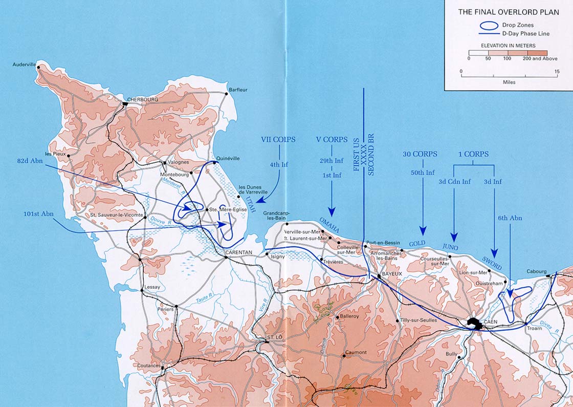
Shortly after midnight on June 6, 1944, 18,000 paratroopers from three airborne divisions—the U.S. 82nd
and 101st Airborne Divisions and the British 6th Division—landed behind the targeted Normandy beaches.
Figure 2 provides the approximate drop locations. Beginning at 6:30 a.m., allied naval forces conveyed
assault forces across the English Channel. Six army infantry divisions—three American, two British, and
one Canadian—landed on Utah, Omaha, Gold, Juno, and Sword beaches. The 2nd and 5th U.S. Army
Ranger battalions were assigned to Pointe du Hoc (sometimes called Pointe du Hoe), a prominent position
along the coast of Normandy.
Figure 1. June 6th, 1944: D-Day by the Numbers
Source: CRS, based on information from the Smithsonian Institution’s “June 6, 1944: A Day That Changed the World”;
U.S. European Command (EUCOM)’s “D-Day: The Beaches”; and the U.S. Army Heritage and Education Center.
Note: The 2nd and 5th U.S. Army Ranger battalions were non-Divisional units, involved at Pointe du Hoc, an important
operational objective. Other non-Divisional units are not represented in this figure.
link to page 2 link to page 4

Congressional Research Service
3
Figure 2. Map of the D-Day Invasion
Source: CRS, based on maps from the U.S. European Command (EUCOM)’s “D-Day: The Beaches”; “The Final Overlord
Plan” (pp. 22-23) in the Army Center for Military History’s “Normandy”; and Wil iam M. Hammond, Normandy: 6 June-24
July 1944, pp. 26-27 (Washington, DC: Army Center for Military History, 2019).
WWII Participation and Casualties
According the U.S. Department of Veterans Affairs (VA), about 16 million Americans served during
World War II. As of 2023, there were approximately 119,550 living World War II veterans, and it was
estimated that 131 World War II veterans die each day. There are no VA statistics on the number of living
D-Day veterans. See Figure 1 for casualties for Allied Forces on June 6, 1944.
Medal of Honor Recipients
According to the National Medal of Honor Museum, four soldiers received the Medal of Honor
(MoH) for actions specifically on June 6, 1944: Pvt. Carlton W. Barrett; 1st Lt. Jimmie W.
Monteith Jr.; Tech. 5th Grade John J. Pinder Jr.; and Brig. Gen. Theodore Roosevelt Jr. An
additional 12 soldiers were awarded the MoH for actions on subsequent days of the Normandy
invasion.
All MoH recipients for D-Day and the overall Normandy invasion were in the U.S. Army.
American Cemeteries, Monuments, and Memorials
The American Battle Monuments Commission (ABMC) manages America’s overseas commemorative
cemeteries and memorials, including the following D-Day-related sites in France and the United
Kingdom. (For a map of the cemeteries and memorials, see Figure 3.)

Congressional Research Service
4
• Normandy American Cemetery, France
• Brittany American Cemetery, France
• Dartmouth Monument, United Kingdom
• Pointe du Hoc Ranger Monument, France
• Utah Beach American Memorial, France
• XI Amphibious Force Marker, United Kingdom
Figure 3. American Cemeteries and Monuments
Source: CRS, based on American Battle Monuments Commission websites.
Additional Resources
Veterans Stories
• Library of Congress, Story Map, “D-Day Journeys: Personal Geographies of D-Day
Veterans, 75 Years Later”
• Library of Congress, VHP (Veterans History Project), “Serving Our Voices: D-Day (June
6, 1944)”
• Library of Congress, VHP, “Operation Overlord (D-Day Normandy Invasion)”
Maps at the Library of Congress
• Library of Congress, “D-Day’s Top-Secret Map”
• Library of Congress, “Planning D-Day: Relief Model of Utah Beach Given to Library”
Congressional Research Service
5
• Library of Congress, VHP, “VHP Collection Spotlight: Joseph Vaghi’s D-Day Map”
Acknowledgments
Amber Wilhelm, Visual Information Specialist, and Molly Cox, Geospatial Information Systems Analyst,
prepared graphics and maps. This Insight builds on earlier research by Barbara Salazar Torreon, Senior
Research Librarian.
Author Information
David A. Blum
Travis A. Ferrell
Research Librarian
Research Librarian
Disclaimer
This document was prepared by the Congressional Research Service (CRS). CRS serves as nonpartisan shared staff
to congressional committees and Members of Congress. It operates solely at the behest of and under the direction of
Congress. Information in a CRS Report should not be relied upon for purposes other than public understanding of
information that has been provided by CRS to Members of Congress in connection with CRS’s institutional role.
CRS Reports, as a work of the United States Government, are not subject to copyright protection in the United
States. Any CRS Report may be reproduced and distributed in its entirety without permission from CRS. However,
as a CRS Report may include copyrighted images or material from a third party, you may need to obtain the
permission of the copyright holder if you wish to copy or otherwise use copyrighted material.
IN12370 · VERSION 1 · NEW
INSIGHTi
Defense Primer: 80th Anniversary of D-Day, June 6, 1944
May 29, 2024
On June 6, 1944, military forces from the United States and several other countries (known together as
the Allied Forces) crossed the English Channel to Normandy, France, during World War II (WWII), in
what is considered the largest amphibious assault in history. This date, known as D-Day, marks the
beginning of the allied campaign to liberate Europe from Nazi Germany. June 6, 2024, marks the 80th
anniversary of this historic assault.
The Allied Forces were composed of a coalition of countries, including the United States, that opposed
Nazi Germany. Figure 1 provides information about the forces that participated in D-Day.
What Is the “D” in D-Day?
The “D” in D-Day is the designation for the first day of any important invasion or military operation. In
this instance, D-Day denotes June 6, 1944, the first day of the operation to land troops on the coast of
Normandy.
D-Day Preparation and Operations
At the Quebec Conference of August 1943, U.S. President Franklin D. Roosevelt and British Prime
Minister Winston Churchill discussed a cross-Channel assault. At the Tehran Conference from November
to December 1943, Roosevelt, Churchill, and Soviet Premier Joseph Stalin discussed military strategy and
the post-WWII period and the Americans and the British committed to a cross-Channel invasion. In
December 1943, General Dwight D. Eisenhower was appointed Supreme Commander, Allied
Expeditionary Forces, and took charge of Operation Overlord, the code name given to the combined land,
naval, and air cross-Channel operation. Tens of thousands of troops, with equipment and supplies,
gathered in England to prepare for the assault. Operation Neptune was the code name given to the
seaborne assault phase.
Normandy in northwestern France was chosen as the landing site because “the Allies would have the
element of surprise. The German high command expected the attack to come in the Pas de Calais region
... where the English Channel is narrowest.” Allied Forces had used a deception operation prior to D-Day
to mislead the Germans into thinking the invasion would occur at Pas de Calais or in Norway. Due to the
deception operation, the bulk of German defensive forces were 150 miles away from the Normandy
Congressional Research Service
https://crsreports.congress.gov
IN12370
CRS INSIGHT
Prepared for Members and
Committees of Congress
link to page 3
Congressional Research Service
2
landing sites. The main barrier left to the invasion force was the “Atlantic Wall,” a German effort to
fortify the Atlantic seacoast with concrete and steel defenses against the Allied Forces.
Allied Landings on June 6, 1944
Shortly after midnight on June 6, 1944, 18,000 paratroopers from three airborne divisions—the U.S. 82nd
and 101st Airborne Divisions and the British 6th Division—landed behind the targeted Normandy beaches.
Figure 2 provides the approximate drop locations. Beginning at 6:30 a.m., allied naval forces conveyed
assault forces across the English Channel. Six army infantry divisions—three American, two British, and
one Canadian—landed on Utah, Omaha, Gold, Juno, and Sword beaches. The 2nd and 5th U.S. Army
Ranger battalions were assigned to Pointe du Hoc (sometimes called Pointe du Hoe), a prominent position
along the coast of Normandy.
Figure 1. June 6th, 1944: D-Day by the Numbers
Source: CRS, based on information from the Smithsonian Institution’s “June 6, 1944: A Day That Changed the World”;
U.S. European Command (EUCOM)’s “D-Day: The Beaches”; and the U.S. Army Heritage and Education Center.
Note: The 2nd and 5th U.S. Army Ranger battalions were non-Divisional units, involved at Pointe du Hoc, an important
operational objective. Other non-Divisional units are not represented in this figure.
link to page 2 link to page 4
Congressional Research Service
3
Figure 2. Map of the D-Day Invasion
Source: CRS, based on maps from the U.S. European Command (EUCOM)’s “D-Day: The Beaches”; “The Final Overlord
Plan” (pp. 22-23) in the Army Center for Military History’s “Normandy”; and Wil iam M. Hammond, Normandy: 6 June-24
July 1944, pp. 26-27 (Washington, DC: Army Center for Military History, 2019).
WWII Participation and Casualties
According the U.S. Department of Veterans Affairs (VA), about 16 million Americans served during
World War II. As of 2023, there were approximately 119,550 living World War II veterans, and it was
estimated that 131 World War II veterans die each day. There are no VA statistics on the number of living
D-Day veterans. See Figure 1 for casualties for Allied Forces on June 6, 1944.
Medal of Honor Recipients
According to the National Medal of Honor Museum, four soldiers received the Medal of Honor
(MoH) for actions specifically on June 6, 1944: Pvt. Carlton W. Barrett; 1st Lt. Jimmie W.
Monteith Jr.; Tech. 5th Grade John J. Pinder Jr.; and Brig. Gen. Theodore Roosevelt Jr. An
additional 12 soldiers were awarded the MoH for actions on subsequent days of the Normandy
invasion.
All MoH recipients for D-Day and the overall Normandy invasion were in the U.S. Army.
American Cemeteries, Monuments, and Memorials
The American Battle Monuments Commission (ABMC) manages America’s overseas commemorative
cemeteries and memorials, including the following D-Day-related sites in France and the United
Kingdom. (For a map of the cemeteries and memorials, see Figure 3.)
Congressional Research Service
4
• Normandy American Cemetery, France
• Brittany American Cemetery, France
• Dartmouth Monument, United Kingdom
• Pointe du Hoc Ranger Monument, France
• Utah Beach American Memorial, France
• XI Amphibious Force Marker, United Kingdom
Figure 3. American Cemeteries and Monuments
Source: CRS, based on American Battle Monuments Commission websites.
Additional Resources
Veterans Stories
• Library of Congress, Story Map, “D-Day Journeys: Personal Geographies of D-Day
Veterans, 75 Years Later”
• Library of Congress, VHP (Veterans History Project), “Serving Our Voices: D-Day (June
6, 1944)”
• Library of Congress, VHP, “Operation Overlord (D-Day Normandy Invasion)”
Maps at the Library of Congress
• Library of Congress, “D-Day’s Top-Secret Map”
• Library of Congress, “Planning D-Day: Relief Model of Utah Beach Given to Library”
Congressional Research Service
5
• Library of Congress, VHP, “VHP Collection Spotlight: Joseph Vaghi’s D-Day Map”
Acknowledgments
Amber Wilhelm, Visual Information Specialist, and Molly Cox, Geospatial Information Systems Analyst,
prepared graphics and maps. This Insight builds on earlier research by Barbara Salazar Torreon, Senior
Research Librarian.
Author Information
David A. Blum
Travis A. Ferrell
Research Librarian
Research Librarian
Disclaimer
This document was prepared by the Congressional Research Service (CRS). CRS serves as nonpartisan shared staff
to congressional committees and Members of Congress. It operates solely at the behest of and under the direction of
Congress. Information in a CRS Report should not be relied upon for purposes other than public understanding of
information that has been provided by CRS to Members of Congress in connection with CRS’s institutional role.
CRS Reports, as a work of the United States Government, are not subject to copyright protection in the United
States. Any CRS Report may be reproduced and distributed in its entirety without permission from CRS. However,
as a CRS Report may include copyrighted images or material from a third party, you may need to obtain the
permission of the copyright holder if you wish to copy or otherwise use copyrighted material.
IN12370 · VERSION 1 · NEW