Volcano and Landslide Provisions in Title X of S. 1460, the Energy and Natural Resources Act of 2017
Title X of S. 1460 would authorize a national volcano early warning and monitoring system (Subtitle A) and a National Landslide Hazards Reduction Program (Subtitle B) within the Department of the Interior (DOI). These activities would be led by the U.S. Geological Survey (USGS), a bureau within DOI.
Volcanoes
The USGS has indicated that progressively implementing a national volcano early warning system (NVEWS) to address a monitoring gap within its Volcano Hazards Program (funding level of $26 million in FY2017) has been a priority since 2005. In its FY2018 budget justification, however, the USGS stated that it planned to suspend implementation of the NVEWS. Subtitle A of S. 1460 would provide an explicit authorization for a NVEWS, including implementation instructions from Congress. Subtitle A is nearly identical to H.R. 4475 and S. 346, the National Volcano Early Warning and Monitoring System Act, as amended.
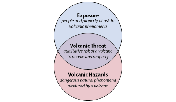
Subtitle A states that the objective of the volcano early warning system is to monitor U.S. volcanoes at a level commensurate with the volcanic threat. The volcanic threat combines the volcano hazards—the destructive phenomena produced by a volcano such as lava flows, ash clouds, volcanic landslides—and the exposure to the hazard (i.e., the people and property at risk from a volcanic eruption). Figure 1 illustrates the intersection of volcanic hazards and exposure.
 |
|
Source: USGS. |
One purpose of the program authorized under Subtitle A is to organize, modernize, standardize, and stabilize the monitoring systems of the five U.S. volcano observatories: the Alaska Volcano Observatory, California Volcano Observatory, Cascades Volcano Observatory, Hawaiian Volcano Observatory, and Yellowstone Volcano Observatory. A second purpose is to unify the monitoring systems of these observatories into a single interoperative system. The legislation would authorize three system components: (1) a 24h-7d national volcano watch office, (2) a national volcano data center, and (3) an external grants program to support volcano research. The legislation would also establish an advisory committee to the program composed of federal agency representatives and other scientists, and would allow for cooperative agreements with academic institutions and state agencies.
The USGS has identified the need for an early warning system since at least 2005, when it published a framework study for a NVEWS. That early study identified 57 priority volcanoes that were undermonitored for volcanic threats. The program authorized by Subtitle A likely would build off that study to identify which volcanoes need new monitoring networks to address threat (Table 1).
|
Region |
Highest Priority |
High Priority |
|
|
Alaska |
Akutan, Amak, Amukta, Augustine, Bogoslof, Cleveland, Fourpeaked, Kasatochi, Kiska, Makushin, Recheshnoi, Redoubt, Seguam, Vsevidof, Yantarni, Yunaska |
Black Peak, Chiginagak, Churchill, Dana, Douglas, Dutton, Edgecumbe, Hayes, Kaguyak, Kupreanof, Spurr, Wrangell |
|
|
Washington |
Glacier Peak, Baker, Ranier, St. Helens |
Adams |
|
|
Oregon |
Crater Lake, Hood, Newberry, Three Sisters |
||
|
California |
Lassen Volcanic Center, Shasta |
Clear Lake, Mono-Inyo Craters, Mono Lake Volcanic Field, Medicine Lake |
|
|
Wyoming |
Yellowstone |
||
|
Hawaii |
Kilauea, Mauna Loa |
Hualalai |
|
|
Commonwealth of North Mariana Islands |
Agrigan, Alamagan, Anatahan, Asuncion, Farallon de Pajaros, Guguan, Pagan |
Sarigan |
Source: USGS.
Notes: 35 volcanoes or regions ranked as highest priority, 20 ranked as high priority. Some regions contain more than one volcano.
Landslides
USGS currently operates, under its Organic Act and other authorities such as the Disaster Relief Act of 1974 (P.L. 93-288), a Landslide Hazards Program (funding level of $3.5 million in FY2017) within its Natural Hazards program. Subtitle B would provide an explicit authorization for a national landslide hazards reduction program within USGS that would broaden its current activities and require coordination with other federal agencies. Its purpose would be to identify landslide risks and hazards from landslides, reduce losses, protect communities at risk, and improve communication and emergency preparedness. The legislation would require the program to map and assess landslide hazards, respond to landslide events, coordinate with states and Indian tribes to identify regional and local priorities, and develop and implement landslide hazard guidelines for geologists, engineers, and land-use decisionmakers. Subtitle B of Title X is nearly identical to S. 698 and H.R. 1675, the National Landslide Preparedness Act.
Subtitle B would structure the program with elements roughly parallel to the long-standing National Earthquake Hazards Reduction Program (NEHRP) last authorized in 2004 under P.L. 108-360. Similar to NEHRP, an interagency committee chaired by DOI would oversee and coordinate the program, and support the development and execution of a national strategy for landslide hazards and risk reduction. Part of the national strategy would include a detailed interagency plan for carrying out the national strategy, with programs, projects, and budgets.
Subtitle B also would establish an advisory committee on landslides, similar to the advisory committee on earthquake hazards reduction in NEHRP. The advisory committee would provide advice and recommendations to the interagency committee on implementing the program, and would include members from states, Indian tribes, research and academic institutions, industry standards development organizations, and emergency management agencies.
The program would develop a publicly accessible national landslide hazards database, and would develop planning and risk reduction guidance, maps, tools, and training materials for state, local, and tribal governments and decisionmakers to assist their efforts in reducing landslide risks. The legislation would expand the early-warning system for flash floods and debris flows, particularly for the increased risk following wildfires. Also, Subtitle B would establish emergency response procedures for rapid deployment of federal assets to areas affected by a landslide event.
Subtitle B would also authorize landslide-related grant programs. DOI would administer a cooperative grant program, available to state, local, and tribal governments for landslide research, mapping, assessment, and data collection. The cooperative grant program would prioritize projects that would achieve the greatest hazard and risk reduction, reflect goals of the national strategy, and have a maximum 50% cost-share. The National Science Foundation would administer a separate research grant program to fund studies also reflecting goals and priorities of the national strategy.