link to page 2 

INSIGHTi
Drought Contingency Plans for the Colorado
River Basin
Updated February 15, 2019
The Colorado River Basin is a critical source of water and power supplies for seven western states and
Mexico. The basin is in the midst of a long-term drought. Water levels at the basin’s two largest
reservoirs, Lake Mead and Lake Powell, could reach critically low levels. Building on prior agreements,
the basin states and the Bureau of Reclamation (Reclamation) recently announced drought contingency
plans (DCPs) that aim to decrease the likelihood of major water and power supply curtailments for users.
Colorado River Basin in Context
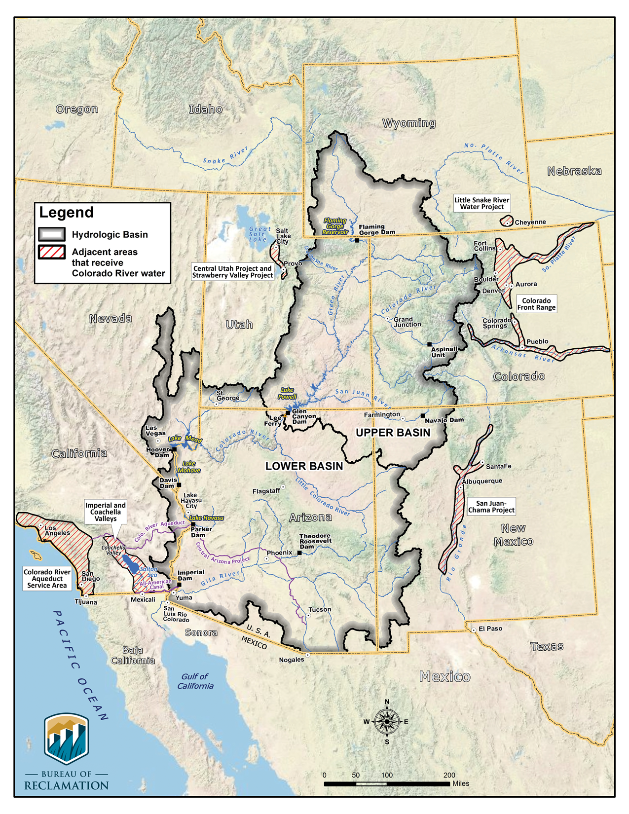
The Colorado River Basin (Figure 1) covers approximately 246,000 square miles, 97% of which are in
the United States. It includes the Colorado River and its tributaries, which cross the U.S. border into
Mexico before discharging into the Gulf of California. Pursuant to federal law, multiple federal facilities
(e.g., Hoover Dam) store and convey water from the river and its tributaries and generate hydropower for
the southwestern United States. The primary federal agency with jurisdiction over the river is
Reclamation, an agency within the Department of the Interior (DOI).
Congressional Research Service
https://crsreports.congress.gov
IN10984
CRS INSIGHT
Prepared for Members and
Committees of Congress

Congressional Research Service
2
Figure 1. Colorado River Basin and Major Facilities
Source: Bureau of Reclamation.
Based on observed data, average natural Colorado River flows in the 20th century were about 15 million
acre-feet (maf) annually. Flows have dipped during an ongoing, long-term drought dating from 2000;
Reclamation estimated that from 2008 to 2018, flows averaged 12.9 maf.

Congressional Research Service
3
Colorado River Compact
The Colorado River Compact of 1922, agreed to by the basin states and the federal government, is the
foundation of the “Law of the River,” which governs water management. Under the compact, water
supplies are divided equally between the Upper Basin and the Lower Basin, with the dividing line at
Lee’s Ferry, AZ (near the Utah Border). Each basin was apportioned 7.5 maf annually. Congress
approved the compact in the Boulder Canyon Project Act of 1928. Multiple other compacts, federal laws,
court decisions, and regulatory guidelines have since been added to the Law of the River. State-level
apportionments were established by documents approved subsequent to the Colorado River Compact.
Pursuant to a 1944 treaty with Mexico, an additional 1.5 maf per year was reserved for flows to Mexico.
Figure 2. U.S. Colorado River Apportionments by State
Sources: Colorado River Compact of 1922, Boulder Canyon Project Act (43 U.S.C. 617), and the Upper Colorado River
Basin Compact of 1948.
Notes: Assumes Colorado River Compact apportionment of 15 maf (7.5 maf to each basin). Does not reflect 1.5 maf to
Mexico under the Mexican Water Treaty of 1944.
Supply/Demand Imbalance
Consumptive use in the basin typically exceeds natural flows, and studies project this trend will lead to a
long-term imbalance in basin supply and demand. The basin has thus far avoided major impacts on
supplies due in large part to its significant storage (60 maf), coupled with the fact that Upper Basin states
have not fully developed their entitlement. However, less water is in storage as a result of the drought.
Additional supply/demand imbalance could result from projected population increases and the
development of tribal water rights, among other things.
Congressional Research Service
4
Drought Contingency Plans
In October 2018, after several years of negotiations, draft DCPs were announced for the Upper and Lower
Basins. The DCPs aim to decrease the likelihood of major supply curtailments and other basin impacts.
They build on a series of prior agreements
2003 Quantification Settlement Agreement (QSA). California agreed to reduce water
use to adhere to its Colorado River water allocation and committed to a path for
restoration of the Salton Sea in Southern California.
2007 Colorado River Interim Guidelines for Lower Basin Shortages and
Coordinated Operations for Lake Powell and Lake Mead. These guidelines included
criteria for “balancing” releases from Lakes Mead and Powell and a mechanism for
storing conserved water in Lake Mead. They also included a schedule of Lower Basin
curtailments in Arizona and Nevada if Lake Mead drops to an elevation of 1,075 feet or
less (i.e., a “shortage condition”). As of January 2019, there was a 69% chance of a
shortage condition beginning in 2020.
2014 Pilot System Conservation Program. This DOI-led effort provided cost-shared
funding for projects to conserve water supplies in the Lower Basin.
2017 Minute 323 agreement with Mexico. This agreement extended and replaced the
previous Minute 319 agreement (2012) with Mexico. It included increased U.S. storage
opportunities for Mexico and a binational plan that would commit Mexico to new
delivery curtailments parallel to those in the Lower Basin DCP.
The Upper Basin DCP would establish a Demand Management Program for the Upper Basin by
authorizing storage of conserved water in Lake Powell. It also would establish 3,525 feet as the target
operational level for Lake Powell. Together, these efforts would decrease the risk of Lake Powell’s
elevation falling below 3,490 feet, at which point reduced hydropower generation and cutbacks to water
users are possible.
The Lower Basin DCP would require that when Lake Mead reaches predetermined elevations, Lower
Basin states would forgo deliveries beyond previously agreed-upon levels. It would further incentivize
voluntary conservation of water to be stored in Lake Mead and commit DOI to conserving 100,000 acre-
feet of water that will be left in the system. The agreement aims to avoid Lake Mead elevations falling
below 1,020 feet.
DCP implementation requires approval by basin states and stakeholders of the DCPs and a number of
related intrastate agreements. Federal actions in the DCPs also require authorization by Congress. On
February 1, 2019, Reclamation Commissioner Brenda Burman announced that basin states had not
completed all of the required steps to approve the DCPs by a previously established January 31 deadline.
Thus, the bureau published a Federal Register notice requesting input from basin state governors
regarding how DOI might reduce the risk of drought in the basin. If the DCPs are completed by March
19, the notice would be rescinded and the DCPs could be finalized with congressional authorization. If
they are not completed, DOI may use its authority to make unilateral water delivery cutbacks in the basin.
Congressional Research Service
5
Author Information
Charles V. Stern
Specialist in Natural Resources Policy
Disclaimer
This document was prepared by the Congressional Research Service (CRS). CRS serves as nonpartisan shared staff
to congressional committees and Members of Congress. It operates solely at the behest of and under the direction of
Congress. Information in a CRS Report should not be relied upon for purposes other than public understanding of
information that has been provided by CRS to Members of Congress in connection with CRS’s institutional role.
CRS Reports, as a work of the United States Government, are not subject to copyright protection in the United
States. Any CRS Report may be reproduced and distributed in its entirety without permission from CRS. However,
as a CRS Report may include copyrighted images or material from a third party, you may need to obtain the
permission of the copyright holder if you wish to copy or otherwise use copyrighted material.
IN10984 · VERSION 7 · UPDATED