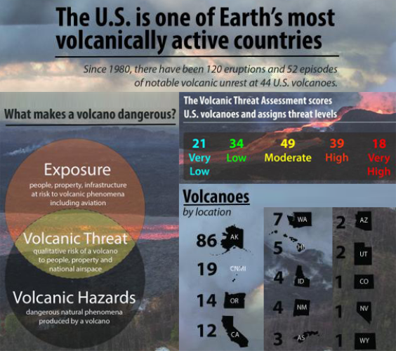
Source: USGS, modified by CRS.
Note: CNMI (19 volcanoes) is Commonwealth of the Northern Mariana Islands; AS (3 volcanoes) is American Samoa.
In 2018, the U.S. Geological Survey (USGS, a bureau within the Department of the Interior), published a volcanic threat assessment that assigned five threat levels (very high, high, moderate, low, and very low) to 161 volcanoes in 14 states and U.S. territories (Figure 1). The assessment ranked 18 volcanoes as very high and 39 as high. Eleven of the 18 very high-threat volcanoes are in Washington, Oregon, or California; five are in Alaska; and two are in Hawaii. The study notes that the high- and moderate-threat volcanoes are mostly in Alaska and that the more explosive Alaskan volcanoes can affect national and international aviation. The volcano ranked as the highest threat is Kilauea, the Hawaiian volcano whose 2018 eruptions were accompanied by destructive lava flows and frequent earthquakes, including one of magnitude 6.9. Kilauea is the youngest and southeastern-most volcano on the island of Hawaii.
|
|
Source: USGS, modified by CRS. Note: CNMI (19 volcanoes) is Commonwealth of the Northern Mariana Islands; AS (3 volcanoes) is American Samoa. |
Section 5001 of S. 47 would authorize a National Volcano Early Warning and Monitoring System (NVEWS) within the USGS. The bill would direct the Secretary of the Interior to establish this system to monitor volcanoes, warn U.S. citizens of volcanic activity, and protect citizens from undue and avoidable harm resulting from volcanic activity. S. 47 was introduced on January 8, 2019, by Senators Murkowski and Cantwell and is on the Senate legislative calendar.
In the 115th Congress, the Senate passed a bill authorizing an NVEWS (S. 346); a similar bill was reported out of committee in the House (H.R. 4475). Legislation nearly identical to S. 346 was included as Title X, Subtitle A, of S. 1460.
USGS has indicated that progressively implementing an NVEWS to address a monitoring gap within its Volcano Hazards Program has been a priority since 2005. USGS asserts that a gap exists between the threat posed by a dangerous volcano and the commensurate level of monitoring needed to assess that threat. Enhanced monitoring also may improve the ability to provide adequate notification and warnings in the event of dangerous volcanic activity.
Currently under its Volcano Hazards Program, the USGS conducts some of the activities (e.g., monitoring, warnings, and notifications) that would be authorized in Section 5001 of S. 47. Congress has appropriated funds supporting these activities but has not yet authorized them explicitly in legislation. Section 5001 of S. 47 would provide an explicit authorization for an NVEWS and would specify that the system's objective is to monitor U.S. volcanoes at a level commensurate with the volcanic threat. Assessing the volcanic threat involves combining the volcano hazards—the destructive phenomena produced by a volcano, such as lava flows, ash clouds, volcanic landslides—and the exposure to the hazard, such as the people and property at risk from a volcanic eruption (see left side of Figure 1).
The legislation states that the NVEWS would have two purposes: (1) to organize, modernize, standardize, and stabilize the monitoring systems of the five U.S. volcano observatories (the Alaska Volcano Observatory, California Volcano Observatory, Cascades Volcano Observatory, Hawaiian Volcano Observatory, and Yellowstone Volcano Observatory) and (2) to unify the monitoring systems of these observatories into a single interoperative system.
The bill would authorize three system components: (1) a 24-hour, 7-day-a-week operational national volcano watch office; (2) a national volcano data center; and (3) an external grants program to support volcano research. The legislation also would establish an advisory committee for the program, composed of federal agency and scientific community representatives, and would authorize the Secretary of the Interior to enter into cooperative agreements with academic institutions and state agencies to designate them as volcano observatory partners for the NVEWS. In addition, the bill would require a five-year management plan for the system, due within 180 days of enactment.
The legislation would authorize USGS to modernize the monitoring system at the volcano observatories within the NVEWS to incorporate emerging technologies, such as digital broadband seismometers, real-time Global Positioning System (GPS) receivers, satellite and airborne radar interferometry, acoustic pressure sensors, and spectrometry to measure gas emissions from volcanoes. These technologies would provide more accurate and real-time or near-real-time measurements, enabling better assessments of the timing and location of volcanic eruption threats. These improvements likely would provide better forecasts of aviation hazards and allow emergency managers to improve evacuation alerts and better position resources to prepare for imminent eruptions.
In its FY2018 budget justification, the Trump Administration proposed suspending implementation of current NVEWS activities within USGS and reducing funding for the Volcano Hazards Program by about $3.6 million (from a total of about $28 million in FY2017). Congress instead chose to increase funding for the program to $42.6 million in FY2018.
In its FY2019 budget justification, the Administration again proposed to reduce funding for the Volcano Hazards Program compared to the prior year (the FY2019 request is for $22.3 million), and it proposed a specific $1.5 million reduction to the NVEWS program activities at USGS.
Section 5001 of S. 47 would authorize a total of $55 million for the NVEWS program to cover the period FY2019 through FY2023. That total would be equivalent to $11 million per year, or about 26% of the overall Volcano Hazards Program budget for FY2018. The bill states that funds made available through its authorization would supplement, not supplant, federal funds made available for other USGS hazards activities and programs.