Map Sources
Links to basic static maps (non-interactive, printable image files) of Iraq and the Middle East region are provided below. Map resources are arranged in alphabetical order, with the exception of the Perry-Castañeda Library website. The Perry-Castañeda Library website description has been placed first because of the exceptional breadth of Iraq maps and links to Iraq maps offered by the library's website.
Perry-Castañeda Library Map Collection: Iraq Maps
http://www.lib.utexas.edu/maps/iraq.html
The University of Texas Website offers a variety of maps, including many maps from the CIA. It also provides some historical maps as well as links to Iraq maps on other websites.
Center for Strategic and International Studies
http://csis.org/files/publication/091001_iraq_war_update.pdf
The Center for Strategic and International Studies report, Recent Trends in the Iraq War: Maps and Graphs, includes such maps as "Key Areas of Shi'ite Extremist Activity" (page 3), and "Ethno-Sectarian Violence, 2006-2009" (page 15).
Central Intelligence Agency Maps
https://www.cia.gov/library/publications/cia-maps-publications/Iraq.html
The Central Intelligence Agency (CIA) creates maps of various parts of the world and makes some available for viewing by the general public on the Internet. Purchase information is provided at this site.
Global Security
http://www.globalsecurity.org/military/world/iraq/maps.htm
Global Security is an online resource that provides background information and news on defense, space, intelligence, WMD, and homeland security issues. Maps found on this website cover administrative, demographic, political, and military topics (including many maps from Department of Defense briefings in 2003 of early Operation Iraqi Freedom military operations).
United Nations (U.N.) Iraq: Web Portal for U.N. Agencies Working in Iraq
http://www.uniraq.org/library/maps.asp
These U.N. maps are arranged into two sections—Geographic and Thematic—and can be searched for specific attributes through the Map Catalogue.
Measuring Security and Stability in Iraq
http://www.defense.gov/pubs/
This Department of Defense source ceased publishing the quarterly reports, "Measuring Security and Stability in Iraq" after June 2010, but these reports can still provide historical data. Each of the "Measuring Security and Stability in Iraq" reports contain maps showing the public views of security in Iraq and the average daily hours of electrical power per province.
New York Times
http://www.nytimes.com/interactive/2007/09/06/world/middleeast/20070907_BUILDUP_MAIN_GRAPHIC.html#
The New York Times has put together an interactive map of post-surge Baghdad neighborhoods, with information on the makeup and outlook of various neighborhoods.
ReliefWeb
http://www.reliefweb.int/rw/rwb.nsf/doc404?OpenForm&cc=irq&rc=3
The Relief website is a project of the United Nations Office for the Coordination of Humanitarian Affairs (OCHA) and offers information and maps on areas of the world requiring humanitarian relief. Maps of Iraq located on this website, dated 2001 through 2010, include "Return to Iraq: 2009-2010" (a map of individuals returning to Iraq after displacement) and "Projects of Japan ODA [Official Development Assistance] Loans in Iraq (as of 31 Mar 2010)."
Report to Congress on the Situation in Iraq, September 2007
http://foreignaffairs.house.gov/110/pet091007.pdf
General Petraeus's September 2007 report to Congress includes a number of maps of Iraq, including "State of Al Qaeda Iraq" on page 20.
Special Inspector General for Iraq Reconstruction (SIGIR)
http://www.sigir.mil/publications/quarterlyreports/index.html
SIGIR provides quarterly and semi-annual publically available reports directly to the U.S. Congress. The April 2010 report includes such maps as "Selected Iraqi Political Protests 2/2011 – 4/2011," "Status of ISPO/USACE Projects, as of 3/31/2011," and "Significant Security Incidents by Region: January 1, 2010 to March 31, 2010" (found below).
United Nations
http://www.un.org/Depts/Cartographic/map/profile/iraq.pdf
This website provides the UN reference map of Iraq in a one-page PDF.
|
Figure 1. Map of Iraq |
Source: CIA maps, provided by the Perry-Castañeda Library, at http://www.lib.utexas.edu/maps/middle_east_and_asia/iraq_pol_2004.pdf. |
|
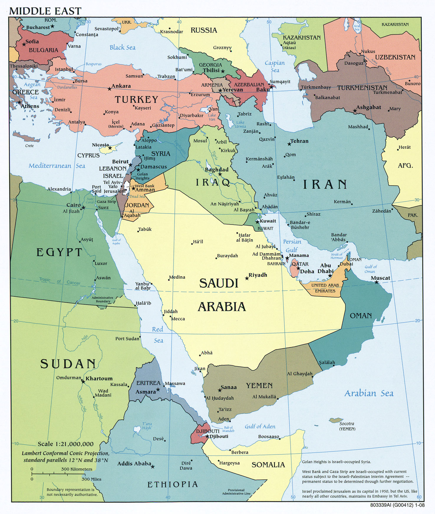
Figure 2. Map of Middle East |
Source: CIA maps, provided by the Perry-Castañeda Library, at http://www.lib.utexas.edu/maps/middle_east_and_asia/txu-oclc-192062619-middle_east_pol_2008.jpg. |
|
Figure 3. Significant Security Incidents: January 18, 2011 to April 18, 2011 |
Source: Special Inspector General for Iraq (SIGIR), Quarterly Report to Congress, April 30, 2011, at http://www.sigir.mil/publications/quarterlyreports/index.html. SIGIR cites the Government of Iraq, U.S., and open-source documents in Arabic and English. |
|
Figure 4. UN Measure of Refugees Returning to Iraq: May 2010- April 2011 |
Source: United Nations High Commissioner for Refugees, "Return to Iraq – May 2010 – April 11," April 30, 2011, at http://reliefweb.int/node/404786. |